.svg@webp)
Drone Duty – a Flight Planner for Photogrammetry
 Lukas
Zmejevskis
Lukas
Zmejevskis

During years of photogrammetric software development, the Pixpro team faced challenges acquiring and processing photographs made for photogrammetry purposes. From terrestrial photogrammetry projects completed with simple cameras or smartphones to massive aerial scan datasets spanning entire towns, we had to do it all to gather the knowledge and the know-how. With today’s drone technology, aerial photogrammetry takes up an ever-larger part of the photogrammetry workflows.
Aerial Photogrammetry
Aerial photogrammetry has unlimited professional and industrial uses. From surveying to 3D asset creation, all photogrammetry experts will use drones for some purpose. Most Pixpro clients use UAVs as a sole source of imagery for photogrammetry projects. We collect feedback on issues and suggestions regarding our Pixpro software and the whole process, including drone use.
There are two main approaches when using a drone to take photos for photogrammetry: manual flight or automated flight. Both methods have their use cases with pros and cons. Automated flights are more used overall as photogrammetry requires a lot of images while being more forgiving about their exact location as long as the overlap is good. To execute a flight plan, you need a flight planning application – a flight planner.
Flight Planners
A flight planner can be a comprehensive and complicated multi-platform software that needs considerable computing resources to run or a sleek and simple mobile app. The former is usually used in more significant operations involving fixed-wing drones with massive area coverage. The latter is the bread and butter of daily 3D scanning using quadcopter drones.
In some cases, drone manufacturers include flight planning software with their products. For example, Yuneec H520 or DJI Phantom 4 RTK drone model remote controllers contain screens preloaded with control applications. The solution is provided right off the bat. But you are stuck with that and depend solely on the provided app. Rarely a single application includes everything needed for everyone or is perfect in most regards.
Most drones do not come with screens and apps built into their remote controllers. Even the DJI Phantom RTK can be used with a remote controller with no built-in screen. Therefore you can use your mobile device, which most people do. Some drone manufacturers provide SDKs for developers to make their applications to control the drone. There are many apps on the market.
Who Makes Flight Planners?
Anyone can make an application used to control drones with publicly available SDKs. This, of course, includes apps made for automated flight. This means that there is an abundance of apps available. With the vast selection comes variation in quality and approach. Some apps may be expensive and complicated, and some are too basic to trust. Some apps offer reasonable control of certain aspects of the flight, while others are neglected.
Our experience when making hundreds of aerial scans using flight planners and manual flying, combined with feedback from clients, industry professionals, and enthusiasts, formed a good understanding of common issues and needs. So we concluded that we could make a competent flight planner with unique features that would be a perfect companion to our photogrammetry software. We started developing Drone Duty.
What is Unique About Drone Duty?
There is no doubt that there are reasonable solutions, and we have stiff competition cut out for us. We hope that ease of use, carefully selected inputs, and automated variables make Drone Duty a worthy competitor.
We observed that many applications do not emphasize how the actual camera part is the most crucial part of the image acquisition. Without good photos, there can be no good 3D scans. Our app gives users complete control of the camera, essential for obtaining well-made images. You can rely on automatic settings or choose to use manual. These include available exposure options, camera focus, and image formats. Your only limit is hardware.
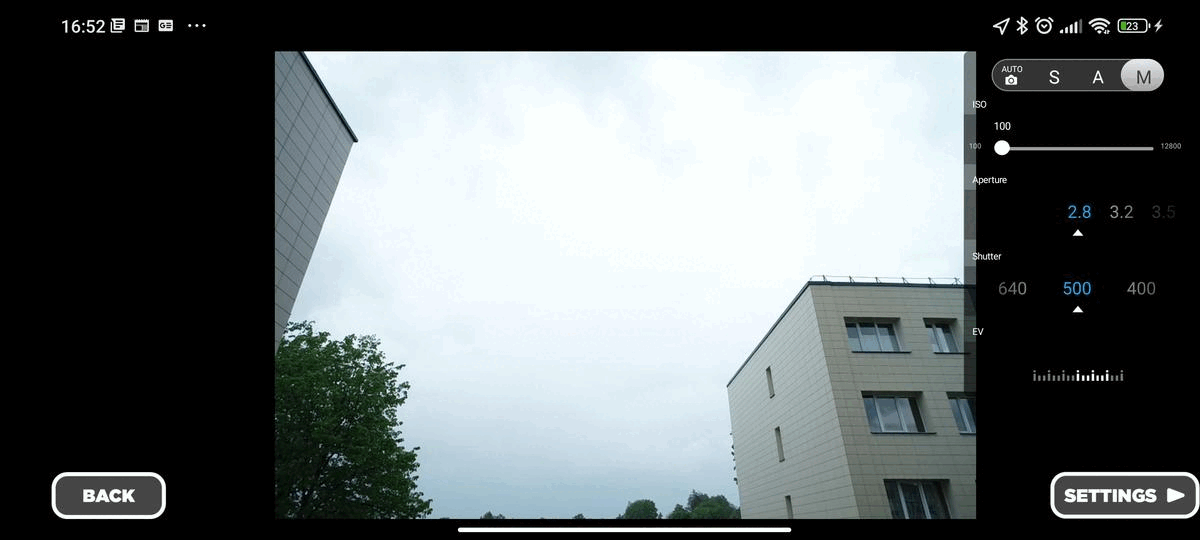
On the other hand, providing too much control can hurt ease of use and the experience of flying. In places, we chose not to add options we deemed unnecessary. For example, we do not differentiate between side and front overlap, which is often the case with other applications. We never observed any benefit in using a different side and front overlap value. Therefore, the overlap is a single percentage setting.
Also, we do not allow oblique angles in single-degree increments because that is excessive without any apparent benefit. We do not provide the ability to choose flight speed in tenths of meters per second. We do not generalize speed as “slow” or “fast,” which is either too granular or not precise. Drone Duty shows the maximum theoretical speed concerning height and camera shutter speed so that the photos can not become blurry. These and many other choices in various aspects of the application make the Drone Duty experience balanced between control and automation while being wrapped in a robust interface.

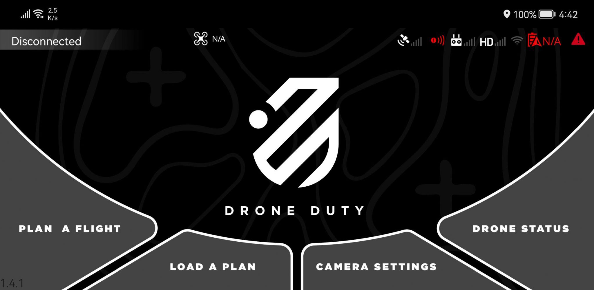
The Interface
One might say our interface is unusual. It is a blend of aesthetics and utilitarianism. No buttons are small or hard to distinguish, and no text is hard to read or confusing. When used with a touchscreen, no information is obscured by your finger, which is often the case when using mobile applications with extensive options. We chose to go with a military/video game layout and style. Solid gray tones provide good contrast and clean aesthetics and hopefully match Drone Duty’s name. We hope to maintain our class, even if the application will get more complex in the future.
Drone Compatibility
Drone Duty is an Android application compatible with DJI Drones at the time of writing. Android is the most popular operating system in mobile devices, and DJI drones are the most common and technically advanced drones readily available in the market. Because of these reasons, we chose to start here. A complete list of compatible drones:
Full support:
Phantom 3 (all models)
Phantom 4 (all models)
Mavic Pro
Mavic 2 Zoom
Mavic 2 Pro
Matrice (all models)
Mavic Enterprise (all models)
Phantom 4 RTK (no screen version)
Inspire (all models)
To an extent:
Spark
Mavic Air
Mavic Mini
Mini 2
Mini SE
Air 2S
Drone Duty Features at a glance:
• 4 Different flight types with variations
• Full camera control
• Wizard-type flight plan execution
• Flight plan saving and loading
• Touch-optimized interface
• Area import from KML files
• Automated flight height calculation in specific plans
• Automated maximum speed calculation
Drone Duty Flight Types
At the time of writing, Drone Duty has four different flight plan types available:
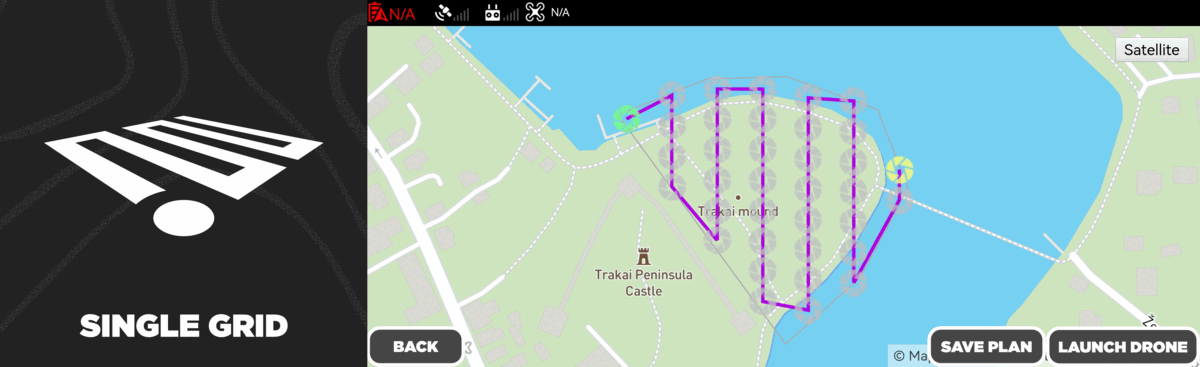
Single grid – the classic single grid top-down scan flight used to capture terrains, mines, and stockpiles and to produce digital elevation maps and orthophoto imagery. Bread and butter of many photogrammetrists, surveyors, and enthusiasts.
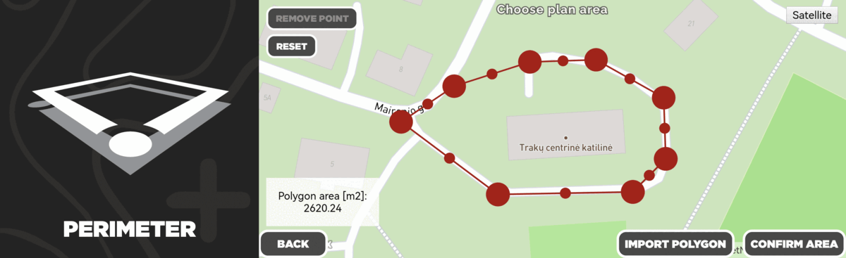
Perimeter – a perimeter flight scan that provides additional information to a single grid scan. It can scan rectangular objects such as houses or stadiums with good detail while maintaining a relatively low amount of images. Our perimeter flight type is unique because it generates the flight altitudes based on your drone’s camera and the designated object’s area and height. This feature ensures that the whole subject is always in the camera’s field of view, and the overlap is always sufficient.
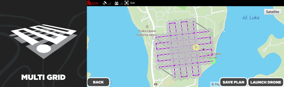
Multigrid – an oblique grid scan type provides a unique ability to change how many angles are captured. If no vertical drone movement is involved, this is the only plan type you will ever need to do detailed scans. It can be used to do a complete 3D scan of an area if four sides are chosen or a single-sided scan if only one face of an object is required. A two-sided scan can be used to capture a single side of a more complex area. Multiple such flights can be combined to achieve the detail you desire.
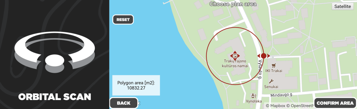
Orbital scan – classic orbital scan but better. The orbit height is generated on the input object height. Two different orbits are executed, thus ensuring the best 3D reconstruction possible. Orbital plans are best for smaller, isolated objects such as roofs, monuments, and smaller buildings. Multiple orbitals can be used to create more extensive scans and in conjunction with other flight plan types.
Future of Drone Duty
We consider Drone Duty to be still at an early development stage with lots of features planned for the future. Currently, we are developing the best possible battery change workflow when a single flight exceeds one battery. As well as better flight time prediction algorithms. Our long term future goals are:
• Adding more drones and manufacturers to the list
• Creating more flight plans, including vertical scanning
• The ability to import flight plans created in Pixpro desktop software
• Convenient multiple battery flight workflow
• 3D camera position preview in the app
• More control over all drone settings and features
• Specific feature development for enterprise clients and industries
• Obstacle avoidance utilization during autonomous flight
Photographer - Drone Pilot - Photogrammetrist. Years of experience in gathering data for photogrammetry projects, client support and consultations, software testing, and working with development and marketing teams. Feel free to contact me via Pixpro Discord or email (l.zmejevskis@pix-pro.com) if you have any questions about our blog.
Related Blog Posts
Our Related Posts
All of our tools and technologies are designed, modified and updated keeping your needs in mind

Accuracy of Your Photogrammetry Project
Accuracy in photogrammetry is a multifaceted point of discussion. We can talk about absolute, relative, or even geometric accuracy, to name a few. No tool or technique can really prove anything beyond reproach.
Buying a Used Drone - Mavic 2 Pro in 2024
Buying used gear is an excellent way to save money and obtain something that may not be on sale anymore. With drones reaching the 4th or 5th technological generation, the used drone market is becoming more extensive.

Photogrammetry Processing - Common Hardware and Software Issues
Photogrammetry requires complex processing and data crunching to turn photos into 3D models. We need a powerful machine to run the software and all its processes. Not only that, but the software within our machine may impact the performance of photogrammetry software in various ways.
Ready to get started with your project?
You can choose from our three different plans or ask for a custom solution where you can process as many photos as you can!
Free 14-day trial. Cancel any time.