.svg@webp)
Pixpro And SolarEdge
 Lukas
Zmejevskis
Lukas
Zmejevskis
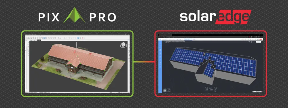
To use photogrammetric data in a specific industry – you need to use specialized tools. SolarEdge designer is a tool for PV professionals that can help to create a simulation and a report of to-be-installed solar panels for residential and industrial roofs. This blog post will look at how to use photogrammetric data to draw and then import accurate lines into Solaredge designer. We will use the lines as a roof framework for the simulations and reporting.
Data Capture
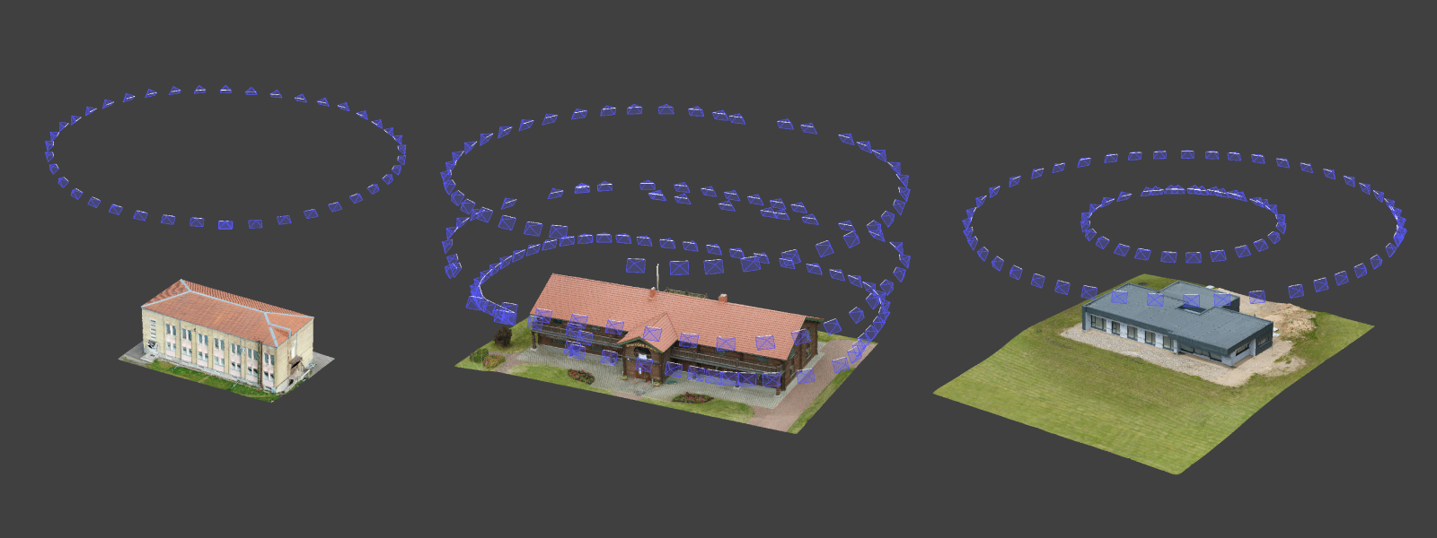
One of the most accessible use cases for aerial photogrammetry is capturing 3D data necessary to draw lines representing roof edges. We can use a single orbit around the roof for residential houses to get a perfectly adequate 3D scene. For large commercial buildings, we can use multiple orbits and nadir scans. This blog focuses on smaller residential roofs – the most common use case. If you want more knowledge on data gathering, read more in other blog posts.
Roof Scanning With Photogrammetry
Measuring Roofs with Photogrammetry
3D Vectors From Photogrammetry
Photogrammetry Fails and Issues Part 1
Photogrammetry Fails and Issues Part 2
Lines in Pixpro
Pixpro software is ideally suited for use alongside SolarEdge Designer as it does have a quick and precise way of drawing lines and exporting them. You can also draw lines without having a 3D mesh layer generated, saving you time. But having a full 3D model is more convenient and visually appealing. Watch the video below on how to draw precise lines in Pixpro.
Export and Import
Once you have all the desired lines representing your roof, you can export these lines as a .dxf file from Pixpro and import them into SolarEdge Designer. A video on how to do that is below:
Editing in SolarEdge
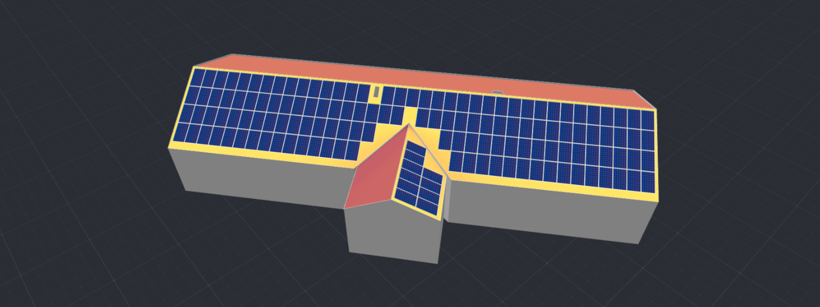
At the time of writing, SolarEdge does not support heights in the .dxf files, meaning you need to add the z-axis measurements manually. It entails going to the 3D view in SolarEdge and adding altitude to each imported line accordingly. It is not a huge issue, as we have the perfect reference in Pixpro. We can get all the measurements in Pixpro and just input that into SolarEdge. Additionally, we can add an orthophoto view from Pixpro, so we do not have to work on lower-resolution map imagery.
With heights transferred from Pixpro, we can start adding solar panels and running other PV-specific calculations. We leave this part to the solar installation professionals.
Conclusion
If you work in the PV industry – photogrammetry is your best tool. We can capture factual information eliminating guesswork and future disputes. We can use Pixpro to measure and draw precise lines and polygons and integrate them with other tools like SolarEdge. Gone are the days of physically inspecting and measuring roofs and putting yourself in danger. Now it is just a matter of taking a few photos with your drone and processing them in Pixpro.
Photographer - Drone Pilot - Photogrammetrist. Years of experience in gathering data for photogrammetry projects, client support and consultations, software testing, and working with development and marketing teams. Feel free to contact me via Pixpro Discord or email (l.zmejevskis@pix-pro.com) if you have any questions about our blog.
Related Blog Posts
Our Related Posts
All of our tools and technologies are designed, modified and updated keeping your needs in mind

Accuracy of Your Photogrammetry Project
Accuracy in photogrammetry is a multifaceted point of discussion. We can talk about absolute, relative, or even geometric accuracy, to name a few. No tool or technique can really prove anything beyond reproach.
Buying a Used Drone - Mavic 2 Pro in 2024
Buying used gear is an excellent way to save money and obtain something that may not be on sale anymore. With drones reaching the 4th or 5th technological generation, the used drone market is becoming more extensive.

Photogrammetry Processing - Common Hardware and Software Issues
Photogrammetry requires complex processing and data crunching to turn photos into 3D models. We need a powerful machine to run the software and all its processes. Not only that, but the software within our machine may impact the performance of photogrammetry software in various ways.
Ready to get started with your project?
You can choose from our three different plans or ask for a custom solution where you can process as many photos as you can!
Free 14-day trial. Cancel any time.