Measuring With Photogrammetry – Pixpro Software Advantage
 Lukas
Zmejevskis
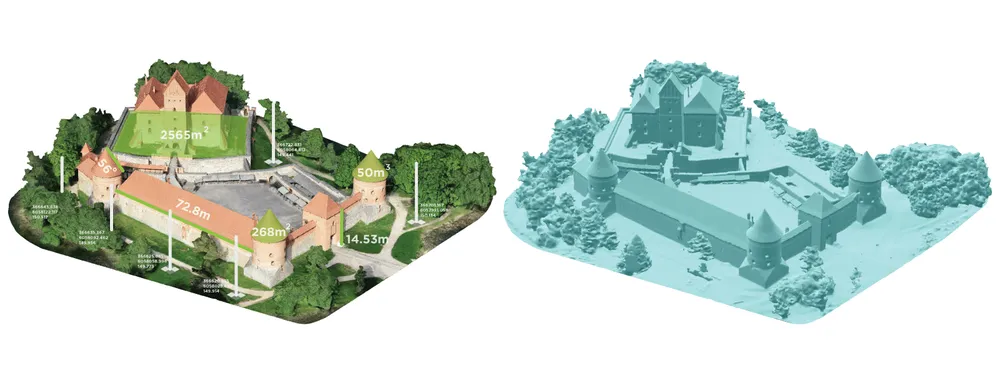
Measuring with photogrammetry can be helpful in many industries and professions. Surveying, inspection, mapping, construction, and other fields require measurements for various goals. With aerial photogrammetry now accessible due to UAV and camera technology, remote sensing has never been this affordable. In Pixpro, we focused on making measurements precise and quick to acquire.
Measuring With Photogrammetry – Prerequisites
Measuring in a Pixpro project requires only the bare minimum of processing. For linear measurements, only a point cloud is necessary. You can even get by using only the sparse point cloud if you need to measure something as quickly as possible. Having a dense point cloud makes things easier, as you can recognize your scene better. And for those wishing to work in a realistic 3D environment – linear measurements can be done on a textured 3D mesh surface.
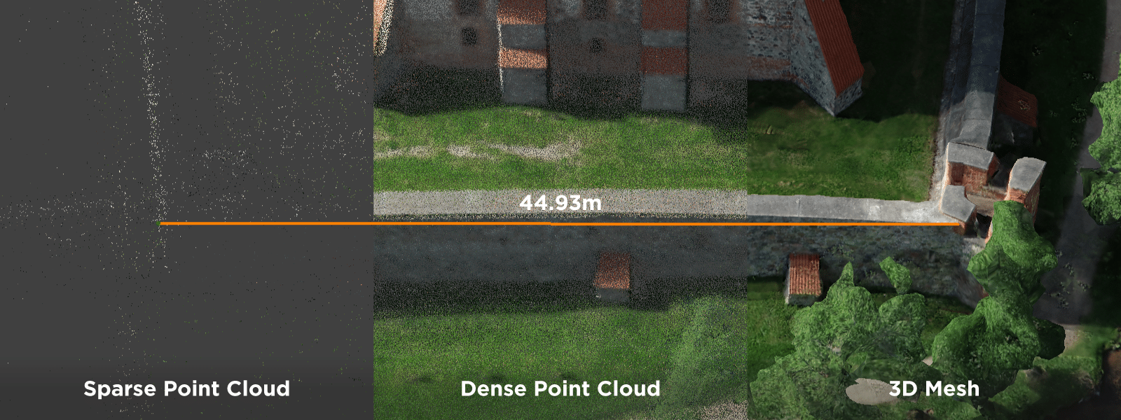
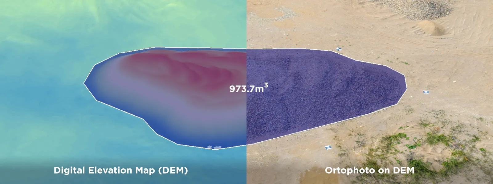
For volumetric 3D measurements, a Digital Elevation Map (DEM) is required. Any point cloud can produce a Digital Elevation Map. A DEM can have an Orthophoto linked to it to make the scene more life-like.
 Measuring With Photogrammetry – Precise Projections
Once you have the required layers, you can begin measuring with Pixpro. Drawing objects in Pixpro provides measurements. There are two approaches to placing objects. You can put it in the 3D view with an approximate location or set it precisely using photo projections. A projection means that the point in 3D space is projected from the designated spot in the images. With good 3D reconstruction in the project, theoretically, any pixel from an image can be shown in the 3D space within the project boundaries.
Points
Point object – used to obtain location data and be an anchor point for other measurements. When a point is placed in the Pixpro project – its location is immediately displayed in the properties panel. Any spot in the 3D space can be designated with a point object. If you choose to place your point object precisely using projections, this point can serve as an anchor for lines and polygons. Pixpro can use snapping to snap any object to a point while maintaining the precision of the initial point.
Lines
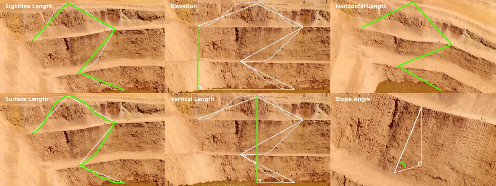
Lines – linear objects are used to obtain linear and angular measurements. When a line is placed, its measurements are immediately displayed in the properties panel. In Pixpro, lines contain the following measurements:
- Horizontal Length is the line length, as seen directly from above, ignoring all other aspects.
- Vertical Length is the vertical distance from the lowest to the highest point in the line.
- Surface Length – line length, including the surface undulations that the line follows. The line must be placed on a DEM to acquire this measurement.
- Sightline Length is the length of the line in a 3D space.
- Slope Angle: relative angle between the first and the last point of the line.
- Elevation: vertical distance between the first and the last point of the line.
 Polygons
Polygons – polygonal objects are used to obtain area and volume measurements. Polygon measurements are as follows:
- Horizontal Perimeter – represents perimeter line length as seen directly from above.
- Area 2D – is the polygon area as seen directly from above.
- Surface Perimeter – is the perimeter line length following all the undulations of the surface. Digital elevation map required.
- Area 3D – is the area measurement within the polygon, including surface roughness and angle.
- Volume 3D (above) – the volume of the surface contained within the polygon above the designated base surface. Digital Elevation Map required.
- Volume 3D (below) – the surface volume contained within the polygon, below the designated base surface. DEM required.
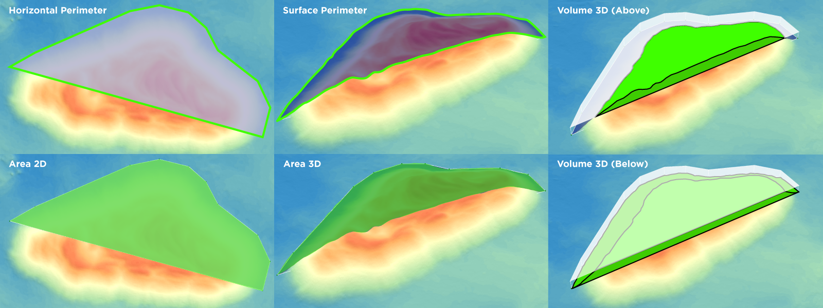
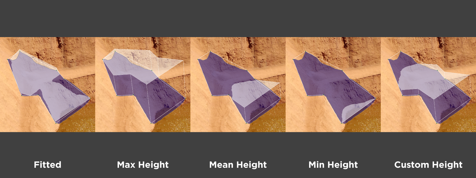
Each polygon contains a base surface. A base surface within the polygon serves as a cutoff point for volume measurements. The selection of a base surface will significantly influence the volume measurements.
In Pixpro, there are six base surfaces:
- Fitted Plane: a plane calculated to fit all marked polygon vertices as best as possible.
- Max Height Plane: a plane at the height of the highest vertice in the polygon.
- Mean Height Plane: a plane at the calculated mean height of all vertices contained in the polygon.
- Min Height Plane: a plane at the height of the lowest placed vertice in the polygon.
- Custom Height Plane: a plane at the user-designated height.
- Elevation Model: surface from another DEM from the current project at the exact location as the drawn polygon.
Profile
A Profile is a visual tool for measuring a cross-section of any line on the Digital elevation map. In Pixpro, any line can be a profile. The profile contains all line measurements but with the ability to select a portion of the line in the visual profile interface. With the profile, you can measure specific parts of the line with the visual reference to elevation changes.
Timeline
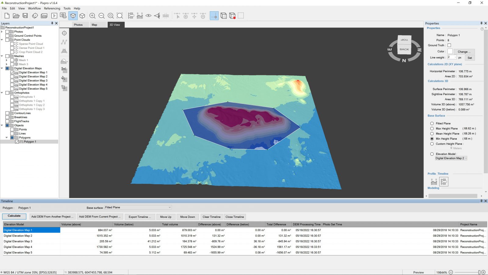
Finally, a Timeline function allows the user to compare volumes in different digital elevation maps using the same polygon. We need Digital Elevation Maps with precise referencing information for timeline functionality to work. The same applies to the Elevation model as a base surface for the volume measurements. If a polygon for these measurements is used in the same spot, there can be no shift between the digital elevation maps, or the measurements may be skewed.
Conclusion
Measuring in photogrammetry can cover an endless amount of use cases. A professional in any mapping, surveying, mining or construction-related industry can easily find use scenarios where aerial photogrammetry would provide a more safe and efficient workflow than traditional methods.

Photographer - Drone Pilot - Photogrammetrist. Years of experience in gathering data for photogrammetry projects, client support and consultations, software testing, and working with development and marketing teams. Feel free to contact me via Pixpro Discord or email (l.zmejevskis@pix-pro.com) if you have any questions about our blog.
Related Blog Posts
Our Related Posts
All of our tools and technologies are designed, modified and updated keeping your needs in mind

Photogrammetry 202 - Pixpro Blog Index
In our final blog post of the year, we are indexing Pixpro photogrammetry blog posts from the last two years. After publishing regularly for a while, things tend to scatter: posts about workflows, Pixpro features, hardware tests, random experiments, use cases, comparisons.

Travel Photogrammetry - More Fun than 2D Photos
Sometimes a 2D photo does not do justice to a moment or a place, and you wish you had something more… dimensional. Something that captures shape, texture, and the little details that flat images tend to flatten even more.
Budget in Photogrammetry - Affordable to Medium to Premium
Photogrammetry, like many other professions, hobbies, or disciplines, can have different budget tiers. In this article, I will provide my opinion on what I consider to be photogrammetry gear, ranging from affordable to premium to high-end tiers.
Ready to get started with your project?
You can choose from our three different plans or ask for a custom solution where you can process as many photos as you like!
Free 14-day trial. Cancel any time.
.svg@webp)