.svg@webp)
Accuracy of Your Photogrammetry Project
 Lukas
Zmejevskis
Lukas
Zmejevskis
Accuracy in photogrammetry is a multifaceted point of discussion. We can talk about absolute, relative, or even geometric accuracy, to name a few. No tool or technique can really prove anything beyond reproach. However, there are a few simple tricks that anyone can use to determine if the photogrammetric 3D reconstruction is close to the real world within a reasonable amount of error.
Scale or Relative Accuracy
The size of your 3D scene is the most straightforward metric to understand and measure. Accurate scale means that the scanned subject is represented in the same size in the project's frame of reference. The reference can be a geographic or local coordinate system in appropriate units.
To put it simply, you need to know the dimensions of your scene to be able to check its scale. This takes some prior planning and preparation. Essentially, you can do a few things before commencing your photogrammetric scan:
-
You can measure the distances between a few key locations, such as corners of a building, pavement, or any other stable structure. Limitations with this kind of method depend on your measuring technique. If you use handheld lasers, surfaces or lighting conditions may be an issue. If you are using measuring tape, you may be limited in the points on perfect planes.
-
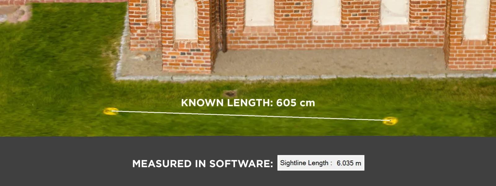
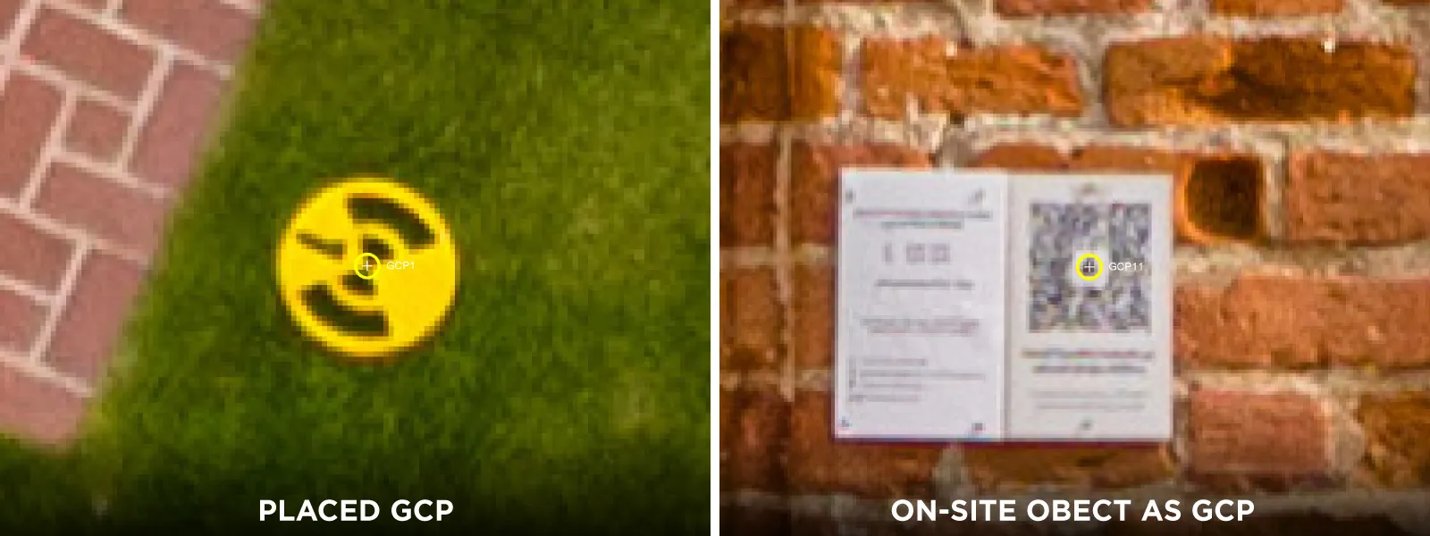
You can bring your own scale bars or markers to measure. The main limiting factors here are the size of a scale bar you can get or the locations of the markers you can place. For any aerial scan, you would need objects of at least 5 meters in length or distance for evaluations. Small-scale bars or markers will not be big enough to be visible in aerial scans.
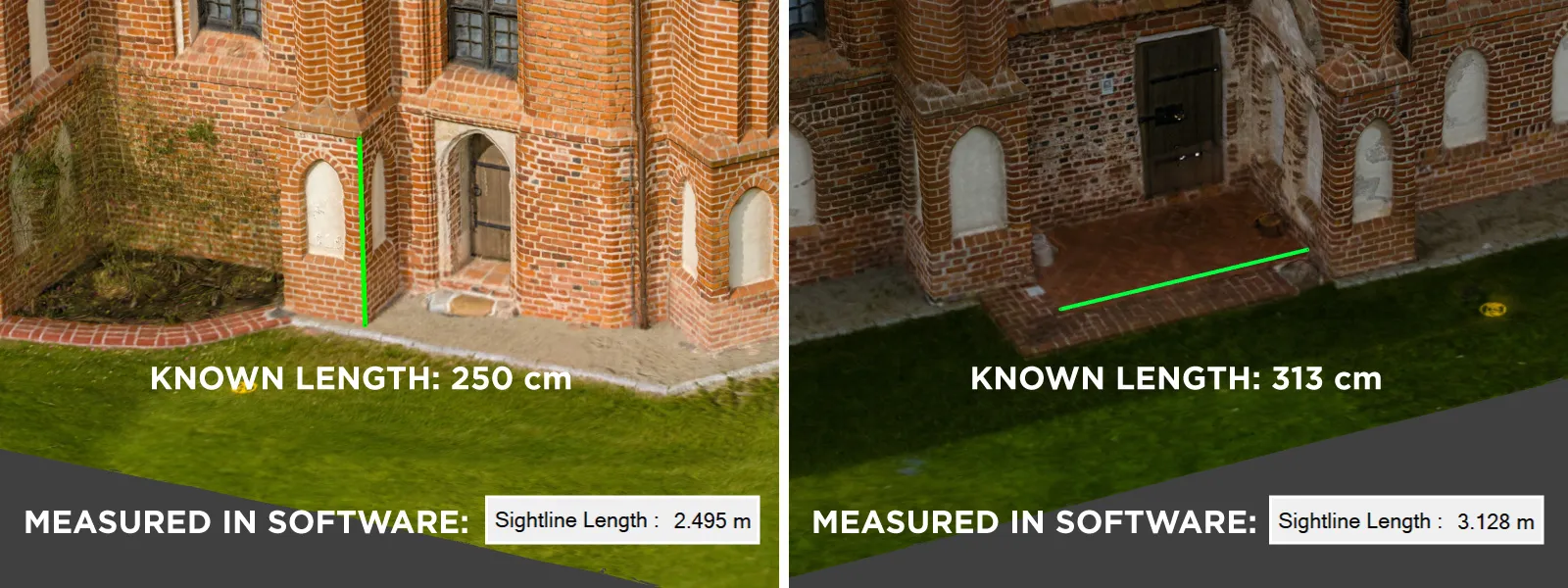
Whichever method you choose - there is one more thing to ensure - you need to measure in a few places at once and in both the XY and Z axes. A photogrammetric 3D scene can have different scales due to distortion if the scene is covered with photos inconsistently. Usually, this is not an issue; measurement in a single location represents the entire project if it is well made.
Problem With Volumes
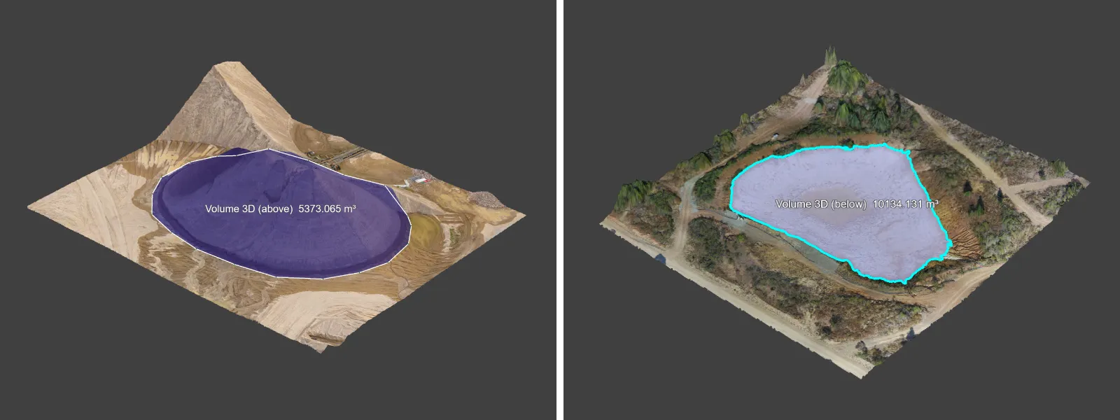
While linear measurements are relatively easy to validate, the same can not be said about volume. Usually, when it comes to volume, many who use photogrammetry measure stockpiles, earthworks, construction, mining, and other types of excavation measure volumes on a massive scale. To validate a volumetric measurement, you need to know the exact volume of something large and stable.
Most material measurements in logistics are derived from weight, and the errors can vary significantly. It may depend on the dampness of the material, the accuracy of the multi-ton scale, and even the ambient temperature. There is the compression of material, which does not affect the weight but affects the volume.
Suppose you wish to validate any volumetric measurements in a scientifically acceptable way. In that case, you will need to do some serious engineering. We considered renting and stacking shipping containers, but volume measurements when measuring something with 90-degree walls behave differently than organic formations.
Position and Geometry Accuracy
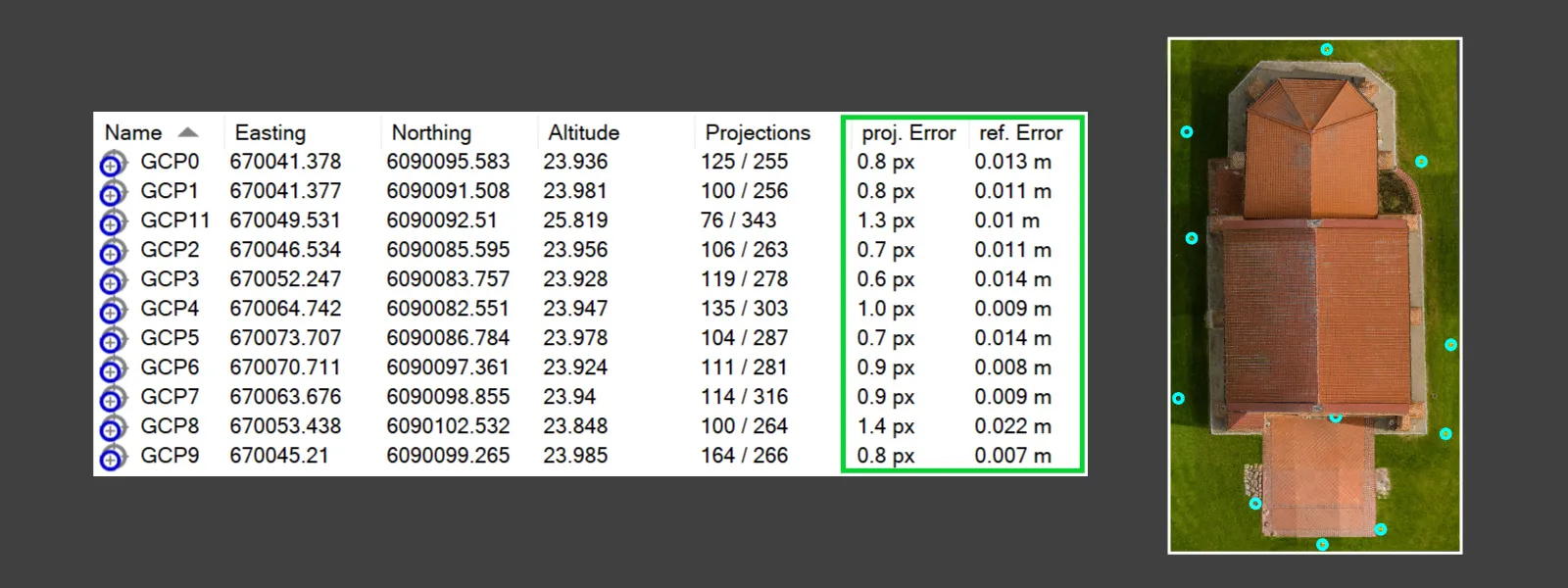
Positional measurement accuracy evaluation requires special equipment or reliable known coordinates in the 3D scene. The method of ensuring the absolute accuracy of a project is using GCPs as a reference for your project. Ground control points are the most accurate referencing type in photogrammetry because the coordinates are present in the captured scene and not "behind" the camera, as with RTK data. So, if you are serious about a project's absolute positioning, you need well-made GCPs.
Determining if a shape on a 3D scene is "correct" is the hardest to validate. If the shape is quite simple, such as a box or something close to a cylinder, you take multiple measurements and compare them with measurements or proportions from the real world. However, such a method is only practical with small enough objects with basic shapes.
We can observe GCP errors to measure positional accuracy and, in part, if the shape of the 3D recreation is accurate to the real world. Each ground control point used in a photogrammetry project will have its errors, representing how far the point is from its GPS location to its projection on the 3D model. The larger this error is - the less accurate the entire 3D reconstruction is implied to be. However, the validity of such evaluations solely depends on the accuracy of the data collected with the GCP equipment and the scale of the project.
What is Most Important for Accuracy
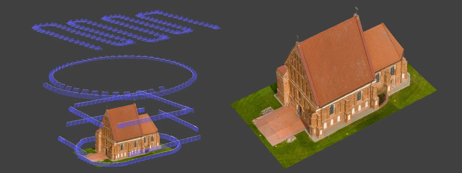
Two factors will determine all types of accuracies in your project - the quality of photogrammetric capture and referencing data. Yes, this is quite obvious, but many often must remember that a poorly made scan can not be fixed by adding good referencing. If a 3D structure of the scan is not contiguous and complete - there is no data to reference. What makes a photogrammetric set good? We have talked about it in several of our blog articles already.
Read more:
Referencing in Photogrammetry - Important Basics
Relative vs Absolute Accuracy in Photogrammetry
Photogrammetry Fails and Issues Part 1
Photogrammetry Fails and Issues Part 2
 Conclusion
In the future, we will share more specific, real-world use cases of measurement validation, as this is an inexhaustible and never-ending discussion between surveyors, photogrammetrists, and other professionals in many fields. In our experience, photogrammetry is an excellent tool for measurements. Good technique and appropriate equipment provide accuracy suitable for many use cases.
Photographer - Drone Pilot - Photogrammetrist. Years of experience in gathering data for photogrammetry projects, client support and consultations, software testing, and working with development and marketing teams. Feel free to contact me via Pixpro Discord or email (l.zmejevskis@pix-pro.com) if you have any questions about our blog.
Related Blog Posts
Our Related Posts
All of our tools and technologies are designed, modified and updated keeping your needs in mind

Photogrammetry Settings: A Practical Capture Checklist
This is a practical photogrammetry settings checklist built around that: the camera and drone settings I actually use, how to handle overlap and flight patterns, what to check before you start, and a cheat sheet at the end you can screenshot.

Top 10 Photogrammetry Misconceptions Part 2 – Advanced Myths
A while back I published a list of the most common photogrammetry misconceptions I kept running into. That post focused on the basics: gear, megapixels, settings, and other things beginners often get wrong.

What Actually Affects Photogrammetry Accuracy?
Photogrammetry accuracy is one of those topics that seems straightforward at first. You take photos, run them through software, and expect accurate results. In reality, it does not quite work like that.
Ready to get started with your project?
You can choose from our three different plans or ask for a custom solution where you can process as many photos as you like!
Free 14-day trial. Cancel any time.