.svg@webp)
RTK Drones: What You Should Know
 Lukas
Zmejevskis
Lukas
Zmejevskis
RTK drones used for drone mapping provide GPS accuracy and order of magnitude better than consumer-grade GPS units. It makes the RTK drones a viable mapping and 3D scanning solution where precision is critical for real-world applicability.
Consumer-grade drones utilize consumer-grade GPS units and compasses. These provide accuracy that can be wildly different depending on various conditions. Environment, location, internet connectivity, and many other factors might limit the overall accuracy of these units. And even if we reach the best possible conditions, we would still measure absolute accuracy in meters.
Hence, other, more profound technologies like RTK are required to guarantee precise mapping and surveying. This article will explain what RTK means and how it works.
What Is RTK?
RTK stands for real-time kinematic. The goal of RTK is to correct GPS location data in real-time while the drone is flying over and surveying the chosen area.
Why is it important? To understand this, let’s compare drones that take advantage of RTK technology with those which do not.
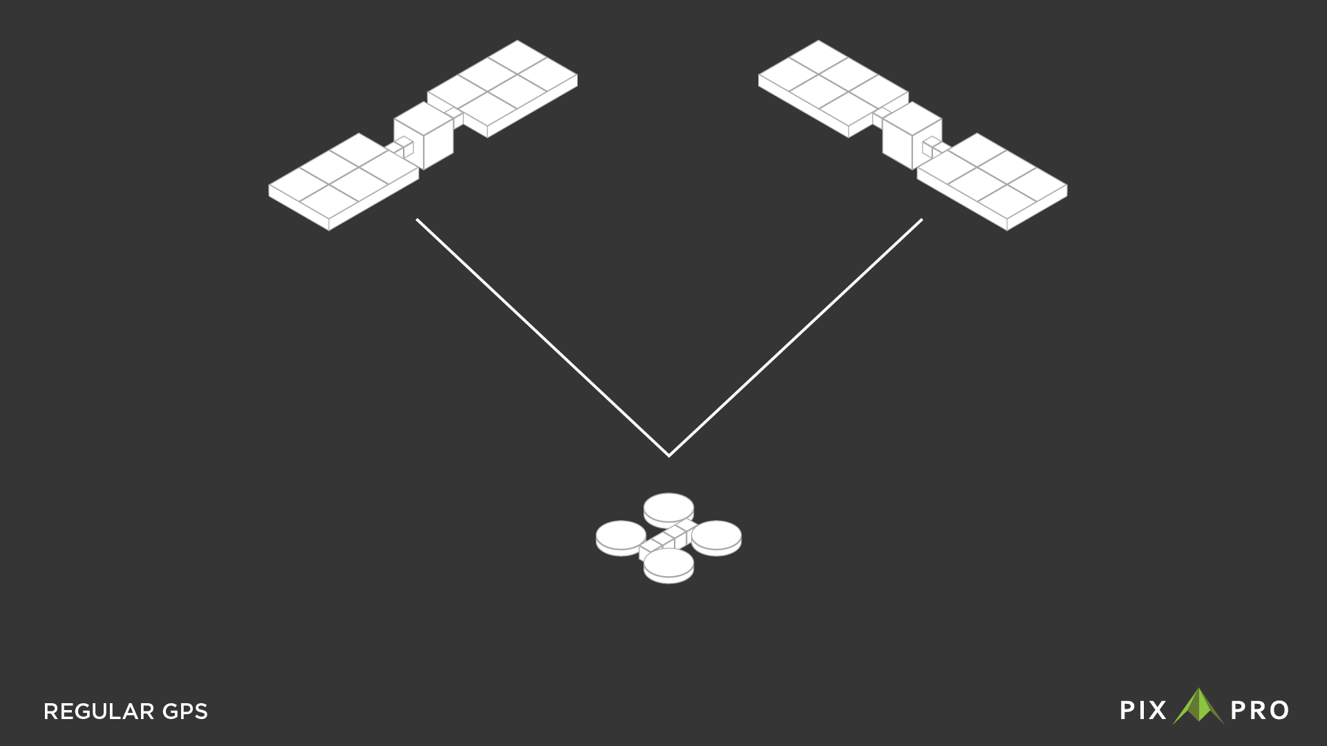
Consumer-grade drones have regular built-in GPS. The drone receives its position data from the satellites. Theoretically, if the drone is working correctly, it will hover in the sky like a tripod without moving. It certainly seems that way when using a drone, but the drone utilizes other sensors to hover in a single spot. Compass, IMU, and visual obstacle avoidance sensors help the drone to be stable. But all of these technologies hide that GPS data is nowhere near precise enough to enable such operation.
The RTK data can be this precise. RTK is the same GPS signal, but it can provide an absolute accuracy of 1 centimeter instead of meters.
How Do RTK Drones Work?
RTK equipped drones use a base station for GPS corrections. A base station is a stationary object with defined precise coordinates. The drone communicates with the base station in real-time, hence the name, and receives GPS corrections multiple times per second.
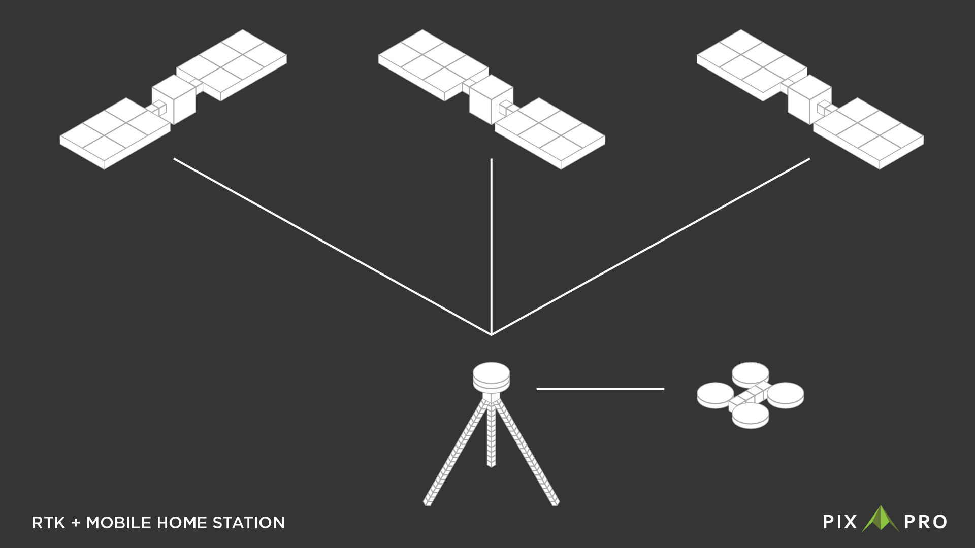
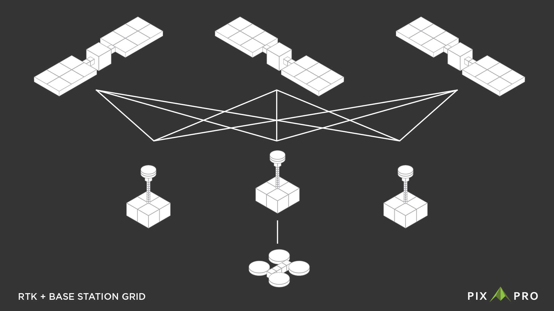
Base stations can be of several types. A portable base station can come in a kit with an RTK drone, which can connect to more satellites than a simple GPS unit and use that data to get a precise location. Or there can be commercial or national base station grids established throughout the country. In this case, the drone connects to this grid via the internet and receives corrections. These grids contain many base stations which already have fixed precise coordinates.
RTK equipment in Lithuania can use the national LITPOS station grid for precise corrections.
In Conclusion
RTK technology is not a new word in the drone industry. Still, it is relevant and in demand, as many businesses choose them to cover needs in drone mapping or surveying.
RTK drones provide a high level of survey-grade accuracy. They demand fewer or almost no ground control points and improve mapping efficiency in different aspects.
Photographer - Drone Pilot - Photogrammetrist. Years of experience in gathering data for photogrammetry projects, client support and consultations, software testing, and working with development and marketing teams. Feel free to contact me via Pixpro Discord or email (l.zmejevskis@pix-pro.com) if you have any questions about our blog.
Related Blog Posts
Our Related Posts
All of our tools and technologies are designed, modified and updated keeping your needs in mind

No. 1 Mistake You Are Making in Photogrammetry Right Now
As photogrammetry software developers, we need to troubleshoot multiple projects from our clients every week. The number one mistake, especially when making measuring projects, is using redundant photos. These photos can appear for a few reasons, which I will describe, and they can be quickly dealt
Classic Photogrammetry with an iPhone
Photogrammetric 3D scanning can turn a bunch of regular photos into a 3D model or a scene. So, we only need a camera and some knowledge of how to take photos. In the previous article, we tested the latest iPhone camera with a few different apps.
Manual Photography with iPhone 16 Pro Max - Android/Windows User Perspective
Adage as old as touchscreens on portable devices tells us that the best camera is the one you have. We have the luxury of having cameras everywhere we go because we are dependent and addicted to smartphones.
Ready to get started with your project?
You can choose from our three different plans or ask for a custom solution where you can process as many photos as you like!
Free 14-day trial. Cancel any time.