.svg@webp)
Smartphone Photogrammetry for Stockpile Scanning
 Lukas
Zmejevskis
Lukas
Zmejevskis
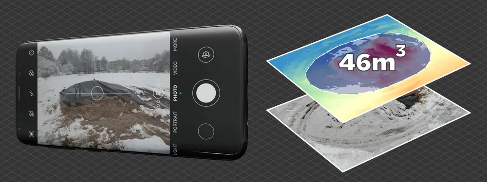
Photogrammetry is accessible to everyone. Nowadays, we carry a device capable of taking decent photos every day, and you only need that to create a 3D model of your own. But what about professional applications? Can you use your phone to take pictures of a stockpile and measure it with applicable accuracy? The answer is yes. With the proper technique, you can measure by taking photos with your phone. Let us look at a specific but practical and common use case for mobile photogrammetry – stockpile scanning.
Volumetric Measurements
We can obtain Linear measurements in physically accessible places using traditional means like tape measures and laser range finders. But even if you have easy access to an irregular pile of material, you can not easily measure its volume and make decisions based on that. 3D scanning techniques such as photogrammetry or lidar come into play. And photogrammetry is the most accessible of them all. You only need a smartphone and Pixpro software to make much more accurate measurements than any experienced eyeball.
Additional Tools
In addition to your phone, you will need some simple tools to scan sizable piles. For volume measurements to be accurate, you must cover the entire scene with multiple photos, including the top part of the pile. If the top part is not visible in the photos, your measurements may skew. Peaks of taller piles will not be visible from a standard human height, so we need to get around that by raising the phone. A long selfie stick with a phone mount or a monopod works best. Anything that will help you to achieve a higher perspective will do.
The second issue we have to deal with is triggering the camera while it is up there. You can use timed shooting with an audio cue, or you can use a physical remote. Some fancier selfie sticks may even have one integrated into the handle. However you approach this issue, the point is to have the camera take pictures without lowering the phone each time.
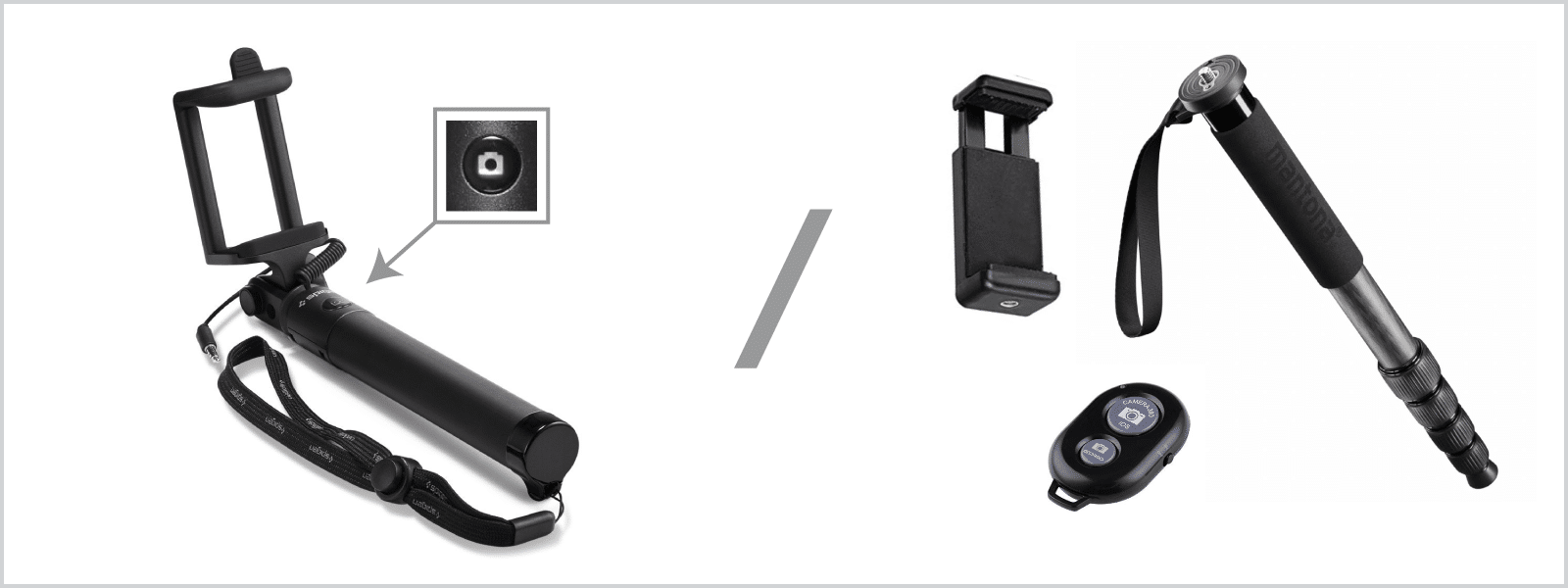
Those looking for the best accuracy in a professional environment may consider adding a GPS RTK module to the phone. The RTK module would dramatically increase the absolute positioning accuracy of the project and will positively affect the measurement accuracy. Usually, the GPS data embedded into photo metadata is enough to scale the project properly but not to place it precisely on the map. The RTK module will help with the placement and consistency of the data. And finally, we always have the option to use Ground Control Points, which is the best solution overall.
Challenges of Smartphone Photogrammetry
The main challenge you will face is pointing the camera correctly while it is up there because you will not be able to see the screen. The easiest way to deal with it is to raise your phone, take a test picture and see how it turns out. If the photograph covers the pile nicely, keep the same angle while moving around the heap of material. Take your time because holding the phone steady with a long pole will be hard.
Keeping track of all the camera settings in your camera will be the second most common challenge. Here are some best practices when doing photogrammetry with your phone camera:
- Use the primary camera and the default “Photo” mode. In some cases, if you have limited space and good lighting, you can use your wide lens if the phone has it.
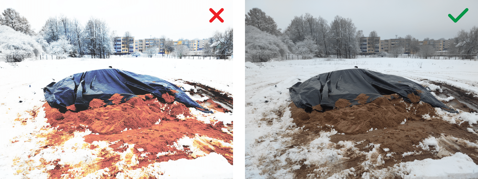
- Do not use any special modes, effects, or processing. Permanently disable HDR, AI, and any filters or post-processing that may be on while using the simple “Photo” mode in the app.
- Do not use any crop modes. Your sensor is at a native 4:3 or 3:2 aspect ratio, meaning every other mode will crop the photo and reduce quality and field of view. Do not use “full,” 1:1, or 16:9 modes while taking pictures.
- Do not use any “high resolution” modes. Turning those on will only slow you down and will not increase the quality of the final result.
- Ensure that the photo quality setting is “high.”
- Be positive that GPS is on and location info for photos is enabled. You need GPS in pictures to have project scaling.
- Clean the camera lens. The camera lens must be clear and clean for the best picture quality.
- Shoot in JPEG format. We do not need RAW or HEIF images for this case.
- Unless you are a professional photographer, leave everything in auto mode.
- Transfer the photos in such a way that they are not resized or altered. The safest way is old school – using a cable to connect your phone to a computer.
To summarize, you have to take simple, vanilla photos without anything added to them. Various post-processing features will introduce inconsistencies and may throw off the photogrammetric algorithms. Smartphone camera apps are notorious for having many features to make photos look “better.” We do not need any of that.
Scanning and Measuring an Example
We made an example using a Xiaomi Mi 11 smartphone mounted on a monopod with a simple phone mount. The scanning technique is straightforward – walk around the perimeter of the pile, ensuring that a large part of the frame is your subject. Take a photo, take a big step, and then retake a photo. Repeat this process until you walk around the whole stockpile. For best results, make two complete walkarounds at two different heights. One height can be at eye level, and one with the phone raised as high as possible.
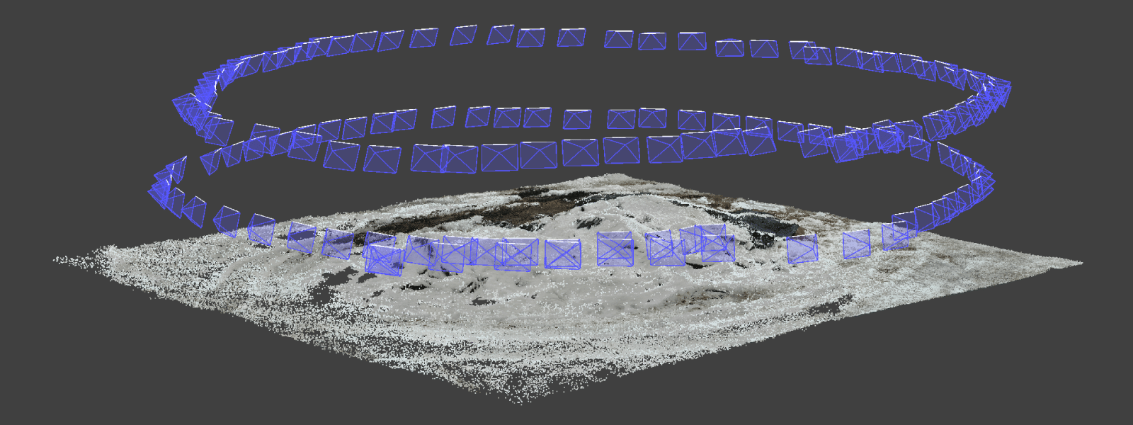
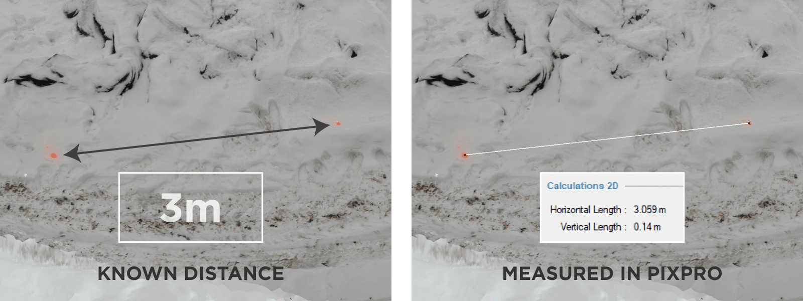
To check how good the scaling is from the GPS information in the photos, we marked two points in the scene, precisely 3 meters apart, and measured them. Our project scaled appropriately, and the measurement was right at 3 meters. If you do the same and see that the scale is wrong, you can use the measured length to fix the scale using manual scaling tools.
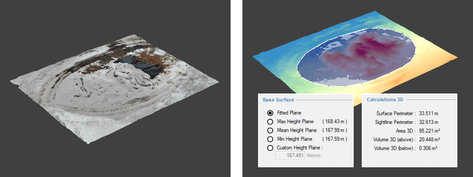
We processed the photos in Pixpro and got a perfectly measurable scene despite the snow and other challenges. Measuring in Pixpro is as easy as drawing a polygon around the pile and selecting a base plane. The whole process of scanning and measuring took less than an hour.
Conclusion
Stockpile scanning with photogrammetry is the easiest way to get a volume measurement of any pile of material. You do not need a professional camera or a drone for smaller or medium-sized piles, and the process will take little time. Just put your phone on a stick to get it higher to ensure that the whole object is visible to the camera, and photogrammetric algorithms will do the rest.
Photographer - Drone Pilot - Photogrammetrist. Years of experience in gathering data for photogrammetry projects, client support and consultations, software testing, and working with development and marketing teams. Feel free to contact me via Pixpro Discord or email (l.zmejevskis@pix-pro.com) if you have any questions about our blog.
Related Blog Posts
Our Related Posts
All of our tools and technologies are designed, modified and updated keeping your needs in mind
A Short History of Photogrammetry: From Balloons to Drones
Photogrammetry feels like something the drone era invented. It did not. The idea of pulling measurements out of photographs is roughly 170 years old, which makes it older than the airplane and a lot older than the computer.

Photogrammetry Settings: A Practical Capture Checklist
This is a practical photogrammetry settings checklist built around that: the camera and drone settings I actually use, how to handle overlap and flight patterns, what to check before you start, and a cheat sheet at the end you can screenshot.

Top 10 Photogrammetry Misconceptions Part 2 – Advanced Myths
A while back I published a list of the most common photogrammetry misconceptions I kept running into. That post focused on the basics: gear, megapixels, settings, and other things beginners often get wrong.
Ready to get started with your project?
You can choose from our three different plans or ask for a custom solution where you can process as many photos as you like!
Free 14-day trial. Cancel any time.