.svg@webp)
DJI Mini 5 Pro For Photogrammetry – Aerial Scanning With Pixpro Waypoints
 Lukas
Zmejevskis
Lukas
Zmejevskis
DJI Mini 5 Pro is a 250-gram flying camera equipped with a 1-inch type sensor. Nine years ago, the Phantom 4 Pro was released as the first consumer drone to feature the same sensor format. At the time, it was a small revolution – the image quality emerging from that camera marked a turning point for entire industries, including photogrammetry, mapping, and inspection.
The Phantom 4 Pro weighs 5.5 times more. It is approximately 25 times larger by physical volume when folded, compared to the Mini 5 Pro. This is not just a technical observation – it highlights just how far drone development has come. What was once a bulky, specialized, and relatively expensive tool is now a pocket-sized machine available to anyone. The Mini 5 Pro is, in many ways, a spiritual successor to the Phantom 4 Pro – now smaller, lighter, and easier to fly, while still delivering comparable results for photogrammetric work.
About the Drone
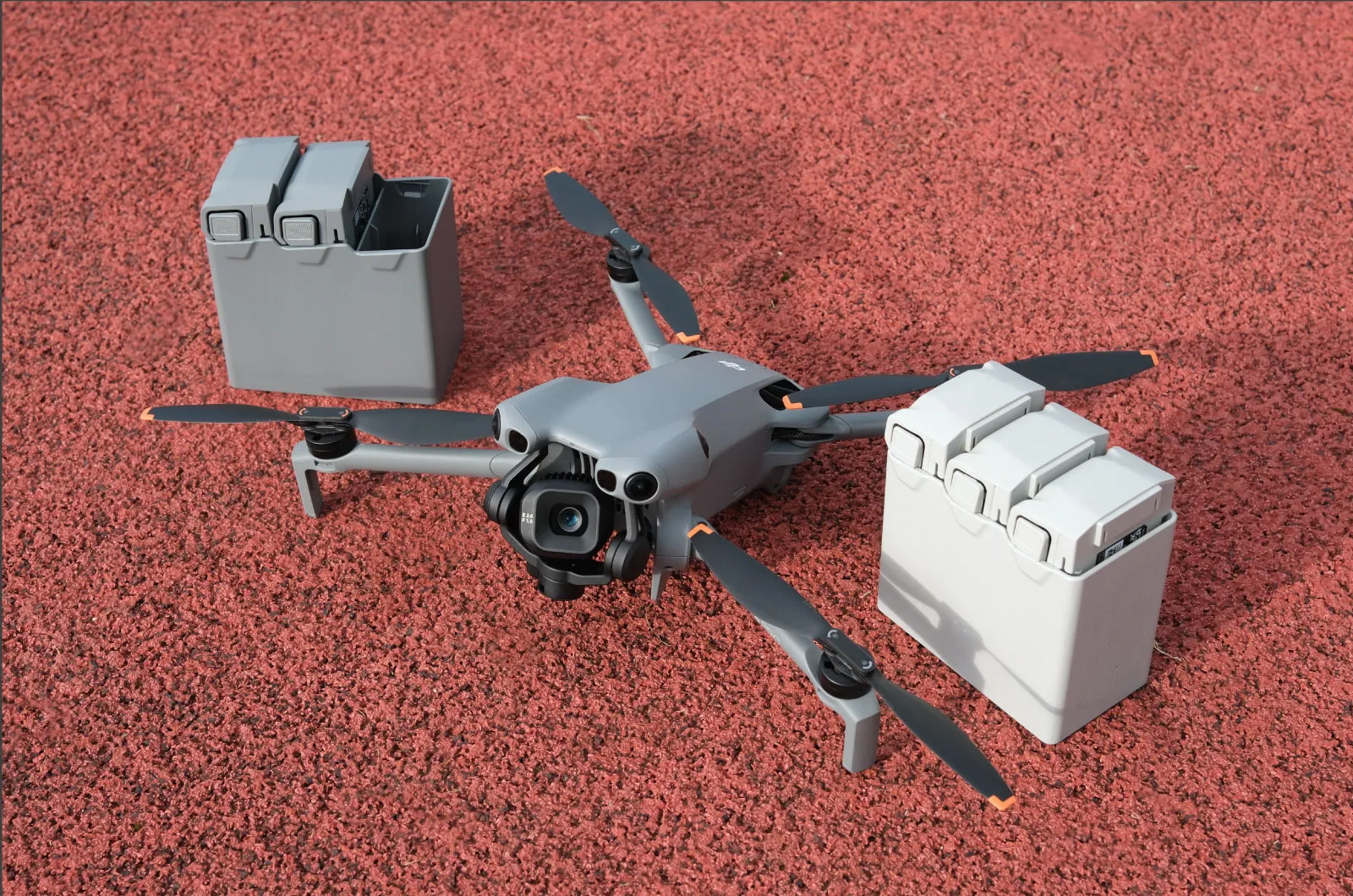
DJI Mini 5 Pro offers all the essential features needed for practical aerial scanning. It includes complete 360-degree obstacle avoidance, with the added benefit of a front-facing LiDAR system that enables obstacle detection even in low light. Its flight time hovers around 25–30 minutes in real-world conditions, and it is the most stable and responsive sub-250g drone on the market.
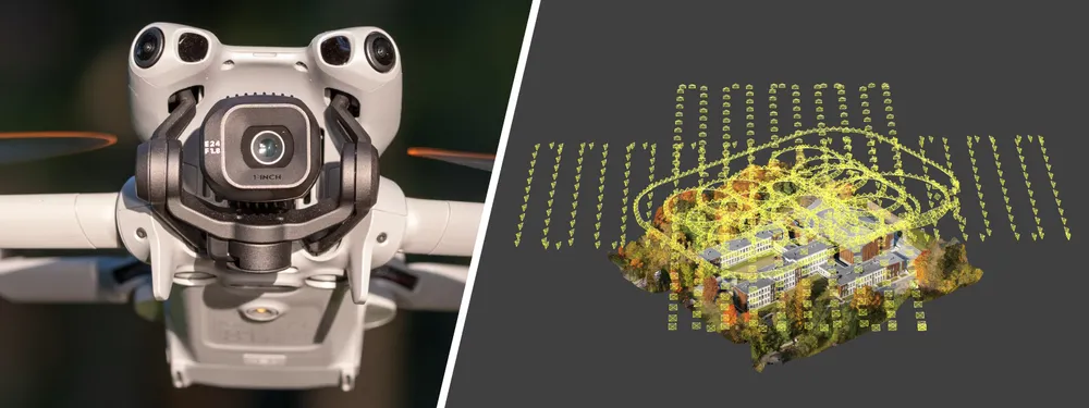
Image quality is the most critical aspect for photogrammetry, and the Mini 5 does not disappoint. It features a 1-inch quad Bayer sensor with a 24 mm equivalent lens and a fixed f/1.8 aperture, producing excellent 12-megapixel photos or 50-megapixel quad Bayer shots with slightly more detail.
 Advantages of Mini 5 Pro
What makes the Mini 5 Pro especially appealing for photogrammetry work is the combination of portability, image quality, and software compatibility. At 249.9 grams, it fits into the C0 class – the least regulated drone category in many parts of the world. This significantly expands the areas and methods for legal flight, particularly in urban environments or near sensitive locations.
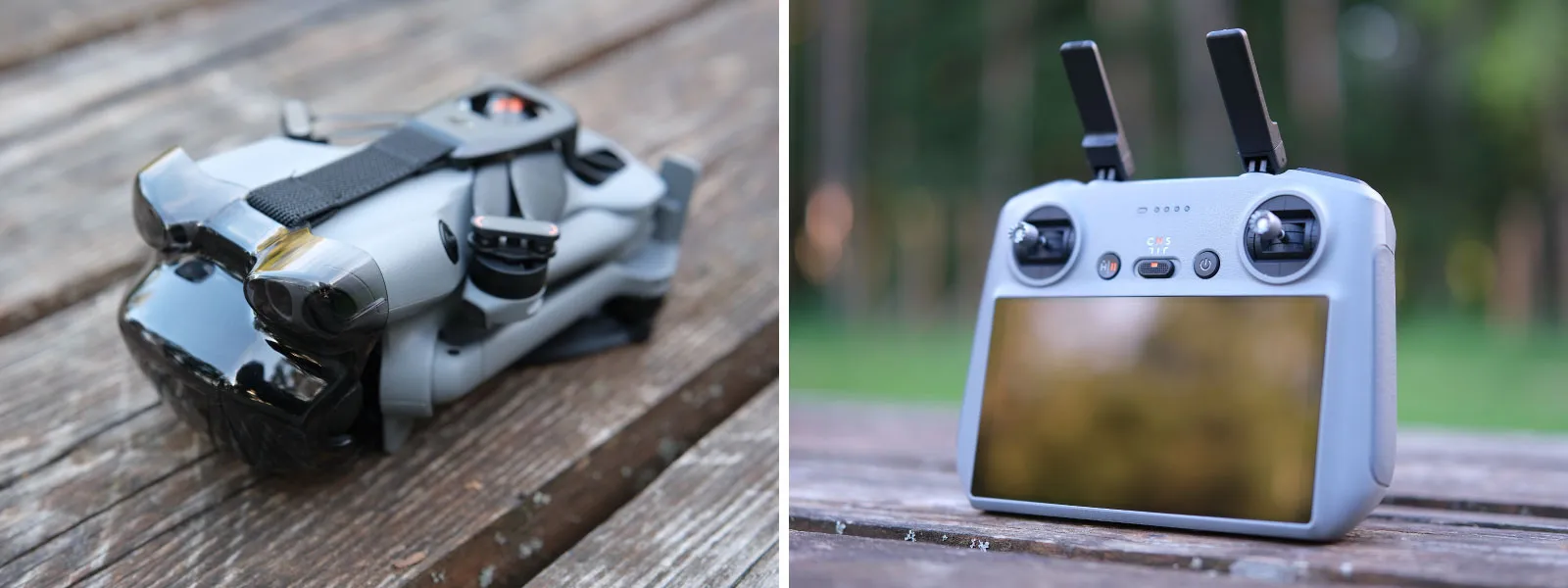
 Pixpro Waypoints compatibility is another major plus. The drone supports fully automated multi-grid and orbital scanning through the Pixpro Waypoints workaround system, while still retaining all the benefits of a high-quality consumer camera. There may be SDK(5) support for the Mini 5 Pro coming in the future, as it was for other Mini Pro drones before it. Still, Pixpro Waypoints are available now, and it does not require using your own device - you can use the far more convenient DJI RC2 remote controller.
 Yes, it lacks RTK capabilities and official enterprise-grade software support, but that is precisely the point. The Mini 5 Pro offers about 80% of the functionality of much larger drones at a fraction of the size, weight, and price. For many use cases, that is more than enough.
Manual and Semi-Automated Photogrammetry
Photogrammetry And The Mini 5 Pro
Mini 5 Pro users can also achieve high-quality scans using manual and semi-automated flight methods. Hyperlapse orbit mode, cruise control, and timed shooting all allow a skilled pilot to manually capture a 3D scan with consistent overlap. Manual grid patterns and freehand oblique passes can also work if one has a good amount of experience.
 In tight spaces or small scan areas, manual capture still holds a significant advantage. The ability to fly close to structures, adjust angle and altitude on the fly, and even walk with the drone for low-level capture makes the Mini 5 Pro an excellent hybrid tool. Once you understand the type of coverage your subject requires, manual methods offer unmatched flexibility in filling data gaps.
Workflow With Pixpro Waypoints
Pixpro Waypoints takes things to the next level by using the built-in DJI waypoint feature and replacing placeholder flights with ones optimized for photogrammetry. With Pixpro Waypoint .kmz files, we can run structured photogrammetry missions on the Mini 5 Pro.
The workflow is straightforward:
- Use the Pixpro Waypoints service to create a flight plan.
- Replace a placeholder waypoint mission on the controller with the downloaded one.
- Execute the flight directly from the DJI Fly app using the built-in waypoint system.
No extra hardware, no unofficial apps – just a clever workaround using DJI’s own tools. The Mini 5 Pro will follow a precise pattern designed for photogrammetry, with photo intervals and angles already accounted for. This allows even complex sites to be scanned automatically with minimal input. Image overlap, one of the most critical factors in photogrammetric scanning, is accurately calculated and addressed.
 Examples in Practice
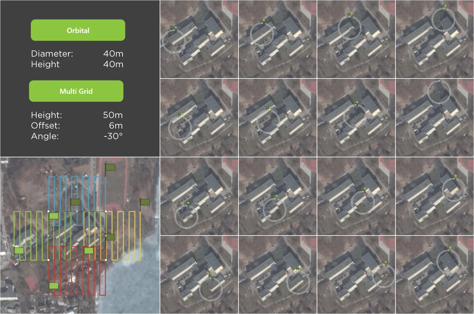
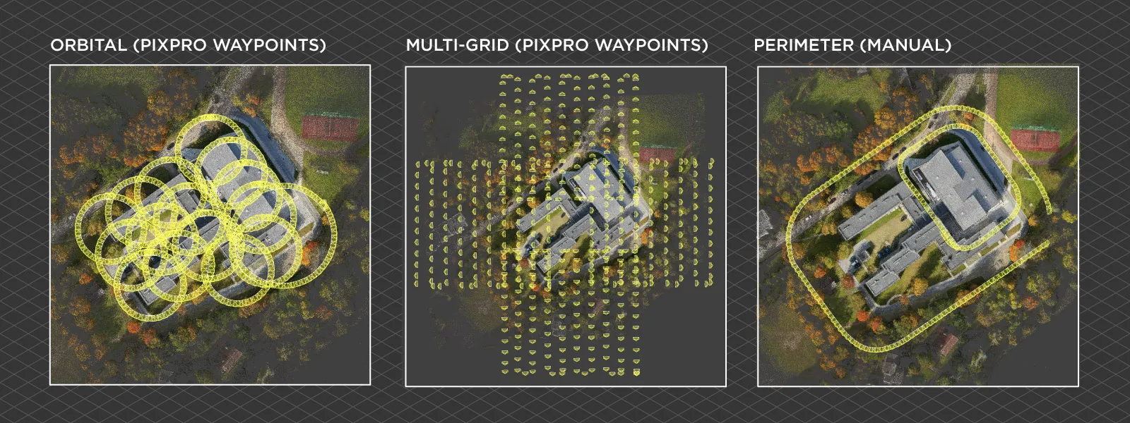
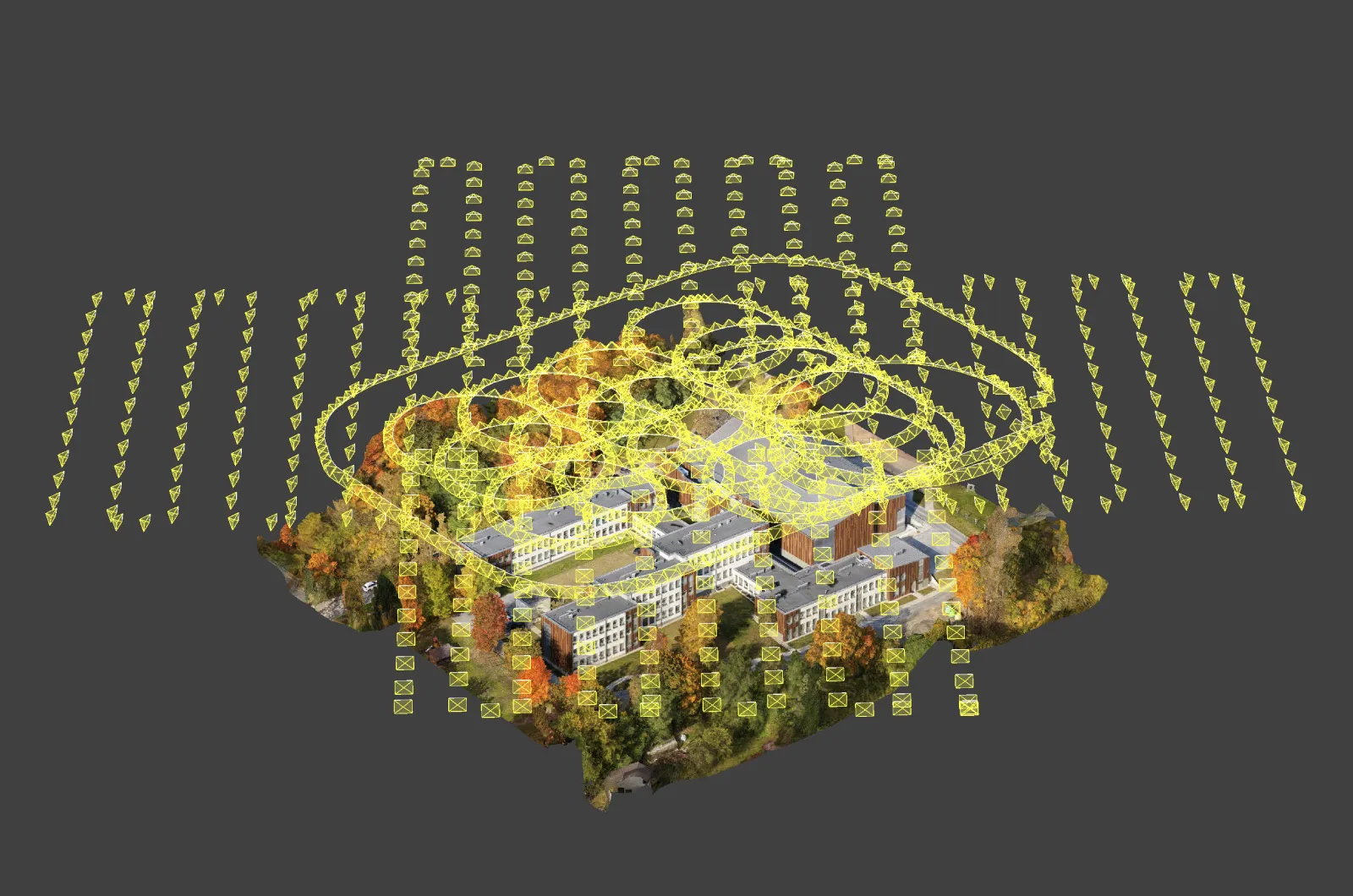
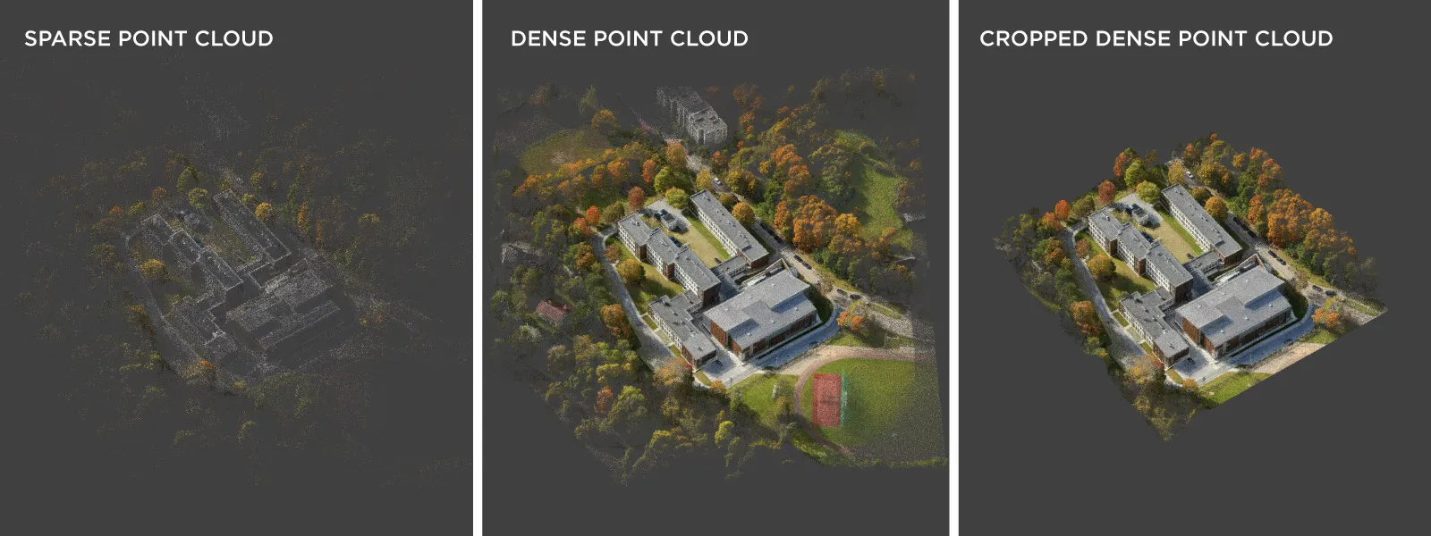
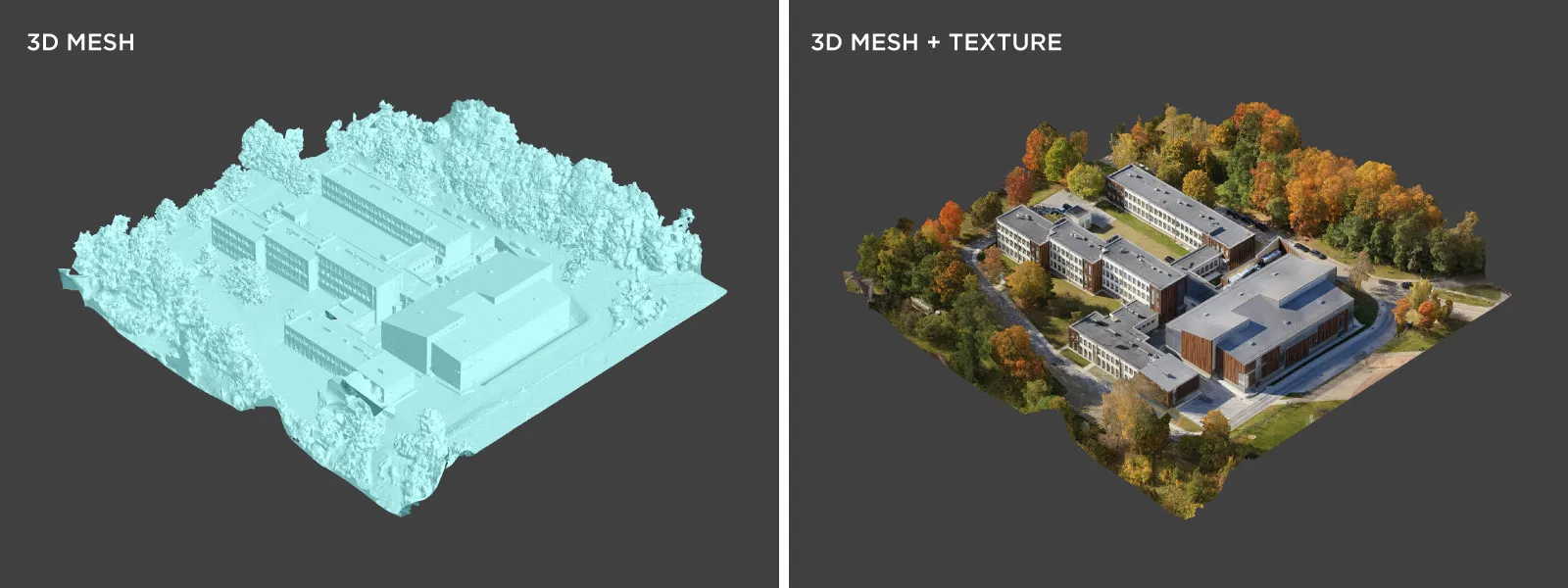
To demonstrate the effectiveness of this workflow, we conducted a comprehensive 3D scan of a newly renovated school complex using the Mini 5 Pro. The scan consisted of all three Pixpro Waypoints flight types:
- A multi-grid oblique flight to capture vertical and roof surfaces.
- An orbital scan for the central structure.
- A manual perimeter flight to add wall detail at low altitude.
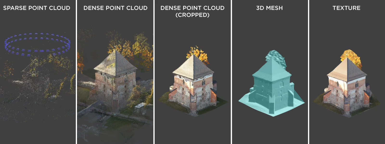
 A total of 1,348 photos were captured and processed using Pixpro photogrammetry software. The resulting 3D model had excellent alignment, high detail retention, and no visible gaps. Despite the modest size of the drone, the final output rivaled what would be expected from larger and more expensive systems.
 This example underscores that with proper planning and execution, even a 250g drone can produce survey-grade 3D scanning results suitable for architectural documentation, inspection, or design planning. Pair that with GCPs, and you have a complete solution suitable even for professional, high-stakes work.
 Conclusion
The DJI Mini 5 Pro is a competent tool for photogrammetry because of its image quality, safety features, and the ability to perform semi-professional scanning workflows in a body that is lighter than many large smartphones. With Pixpro Waypoints, this small drone becomes a professional-grade tool for photogrammetry. It can execute complex flight plans, gather hundreds of usable images, and produce full 3D reconstructions that rival data from drones several times its size and price.
For many small to medium-scale projects — especially in environments where heavier drones are restricted or overkill — the Mini 5 Pro hits the sweet spot. Add a bit of skill, understanding of coverage, and the proper scanning technique, and this drone becomes more than enough. For many people, this will be the new standard tool for photogrammetry work.
Photographer - Drone Pilot - Photogrammetrist. Years of experience in gathering data for photogrammetry projects, client support and consultations, software testing, and working with development and marketing teams. Feel free to contact me via Pixpro Discord or email (l.zmejevskis@pix-pro.com) if you have any questions about our blog.
Related Blog Posts
Our Related Posts
All of our tools and technologies are designed, modified and updated keeping your needs in mind

Stockpile Volume Measurement With Drone Photogrammetry: A Practical Guide
Measuring a stockpile sounds trivial until you actually have to do it on a real site. You need a number you can defend at the end of the month, and you would rather get it without sending somebody to climb up a 10 meter mountain of gravel with a GPS pole.
DJI Lito X1 for Photogrammetry
Can the Lito X1 be used for photogrammetry? Yes it can. Can it produce good results? Yes it can. How to do it? Yes it… well, that is what the rest of this article is for.
Pixpro Waypoints – Frequently Asked Questions Part 2
Pixpro Waypoints service is a workaround solution providing automated photogrammetry flights for the latest DJI drones. The service came about when DJI officially discontinued SDK support — and therefore third-party app development — for consumer-grade drones.
Ready to get started with your project?
You can choose from our three different plans or ask for a custom solution where you can process as many photos as you like!
Free 14-day trial. Cancel any time.