.svg@webp)
Pixpro 1.8.0 - New Reconstruction Core, Adaptive Mapping and Slope Maps
 Paulius Bagdonas
It has been a while since the last version post on this blog. Pixpro 1.8.0 is the first new major version since 1.7.0, and the biggest change sits right at the start of every project: how the cameras get placed and the sparse point cloud gets built. There is a lot more in it too, so here is what is new, where to find it, and what to check before you update.
Previous versions:
- Pixpro 1.7.11 - Seamless Model Sharing
- Pixpro 1.7.10 - Inspections
- Pixpro 1.7.9 - 2025 Goals and Expectations
- Pixpro 1.7.8 - Timeline and Speed
The Short Version
- A new reconstruction core with two new mappers, Global and Triangulation, alongside the existing Incremental and Hybrid.
- A new Mapping Effort setting. The default, Adaptive, tries several mappers in turn and keeps the best result, so most users can simply leave it alone.
- Extended Referencing, a new option for photo sets where consumer drone GPS leaves the model tilted or shifted.
- A new Slope Map layer that colors a DEM by steepness.
- Circle and Rectangle drawing tools, meshing for imported point clouds, much faster layer preparation, and a long list of stability fixes.
- Converted projects cannot be opened in older versions, so keep a copy if you need one.
A New Reconstruction Core
A mapper is the part of the reconstruction that works out where every camera was and builds the sparse point cloud. Everything that follows, the dense cloud, the mesh, the DEM and the orthophoto, is built on top of that result, so it is the step that most decides whether a project succeeds. Pixpro now has four mappers:
| Mapper | How it works | Needs GPS? |
|---|---|---|
| Global (new) | Solves the whole scene at once, using photo GPS positions and gimbal angles when they are available | No |
| Triangulation (new) | Places the cameras directly at their recorded GPS positions and orientation angles, builds the scene from the photo matches and refines it with bundle adjustment | Yes, always |
| Incremental | Adds photos to the reconstruction one by one, the default in earlier versions | No |
| Hybrid | Changes how the reconstruction begins, which helps with large photo sets | No |
According to the developers, Triangulation is the fastest of the four and Global comes next, with both faster than Incremental. The difference is most noticeable on photo sets above roughly 800 to 1,000 photos. Global is the only one of the fast mappers that also works without GPS, so it suits geotagged drone sets in general as well as photo sets with no positions at all. Triangulation is the fastest option for RTK drone sets.
Both new mappers also handle GPS problems on their own. They detect badly positioned photos and re-align or exclude them automatically, and they cope with partly geotagged sets by adding the photos without GPS one at a time. Triangulation also detects when photos only have standard, non-RTK GPS accuracy and refines the camera positions in an extra step.
Mapping Effort Presets
Instead of picking a mapper by name, you now choose a Mapping Effort preset. It lives in the 3D Reconstruction Parameters window, under Advanced Properties, in the Mapping options. The Processing Speed setting in the main window (Fast, Medium, Slow) is unchanged.
| Preset | What it runs |
|---|---|
| Adaptive (default) | Global, then Incremental, then Hybrid, then Triangulation |
| Extended | Incremental, then Hybrid, the same as earlier Pixpro versions |
| Thorough | Incremental only |
| Moderate | Hybrid only |
| Light | Global only |
| Minimal | Triangulation only, shown only when the photos have GPS data |
Adaptive is the interesting one. It runs the mappers in the order above, and as soon as one of them registers more than 85 percent of the photos, Pixpro uses that result and skips the rest. If none of them gets there, it keeps whichever result registered the most photos. The 85 percent threshold is fixed and came out of experiments on Pixpro Cloud processing.
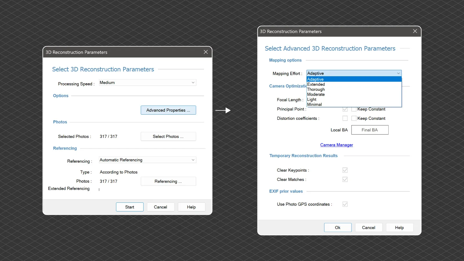 In practice that means most users can leave Mapping Effort on Adaptive and stop thinking about mappers. If you know your data well, for example an RTK drone set, you can pick a single mapper directly and skip the attempts that would not have helped. Choosing a preset applies its recommended camera optimization settings automatically, the progress window shows which mapper is running and which attempt it is on, and the project Summary lists both the preset you chose and the mapper that was actually used.
Pixpro Cloud processing now runs the same mapper sequence as the desktop Adaptive preset, so local and cloud reconstructions follow the same logic.
Read more: Layer creation in the Pixpro help
Extended Referencing
Consumer drone GPS is good, but not always good enough. Sometimes a handful of photos with poor positions is enough to leave a whole model slightly tilted or shifted, the classic sign being a building that does not quite stand straight.
 Extended Referencing is a new checkbox in the Referencing section of the 3D Reconstruction Parameters window. When it is on, Pixpro repeats the GPS referencing up to five times. Each attempt leaves out a further 20 percent of the photos whose GPS positions fit worst. It stops as soon as an attempt gives a good result, and otherwise keeps the attempt with the smallest referencing error. The photos it leaves out are only excluded from the referencing, they are still used to build the 3D model. It works with photo GPS data only.
Extended Referencing sometimes helps, but not always. If a model is still tilted with it on, the reliable fixes remain the same as before: ground control points or manual referencing.
Read more: Referencing in the Pixpro help
Slope Map
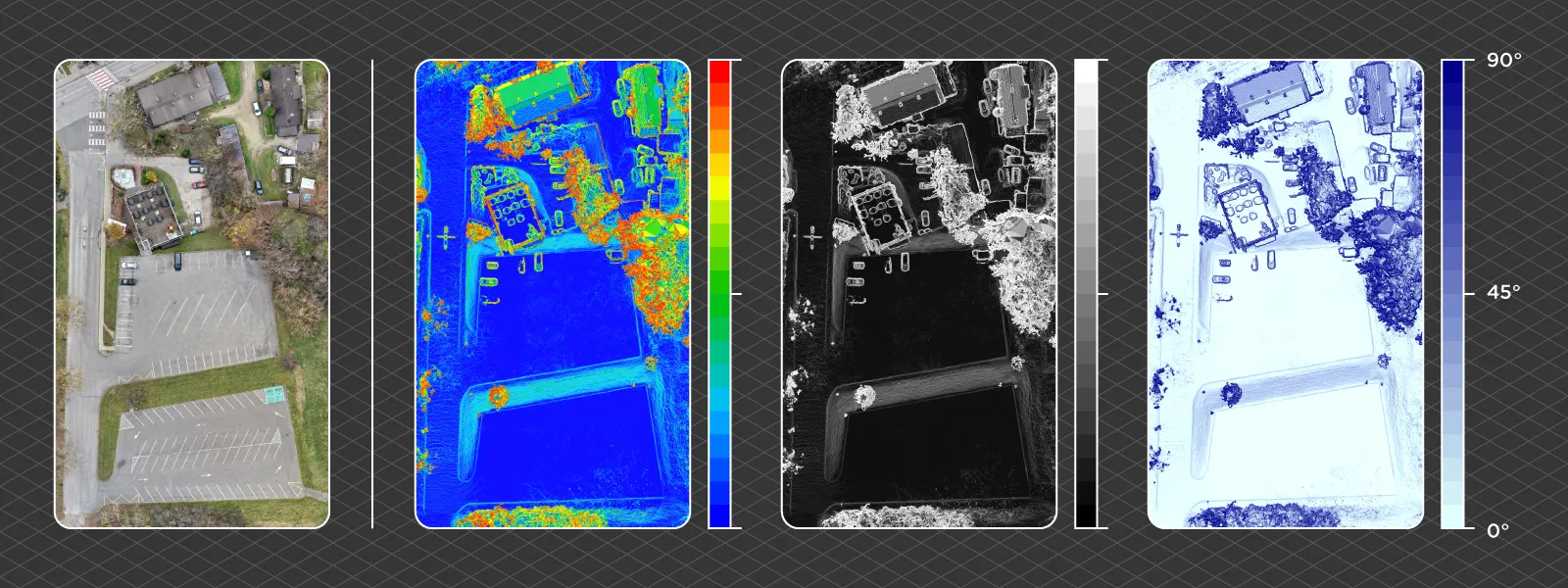
A new layer type. Right click a generated DEM and choose Create Slope Map, and Pixpro calculates the slope angle for every cell and colors it from 0 degrees, flat, to 90 degrees, vertical. In the dialog you choose the elevation model, the slope map GSD and one of 18 color palettes, with Rainbow as the default and options like Greys, Spectral, Hot to Cold and Jet.
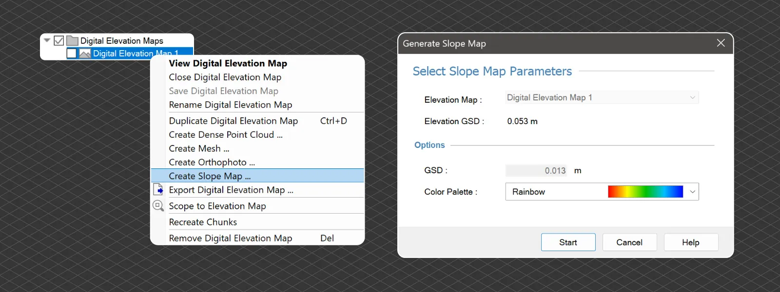 The result appears in the Orthophotos layer group and is viewed and exported like an orthophoto, as a GeoTIFF. A few ideas for what to use it for: spotting steep or unstable slopes, planning earthworks, checking drainage, or keeping an eye on quarry and mine faces.
Circle and Rectangle Tools
Two new drawing tools in the vertical toolbar of the 3D view.
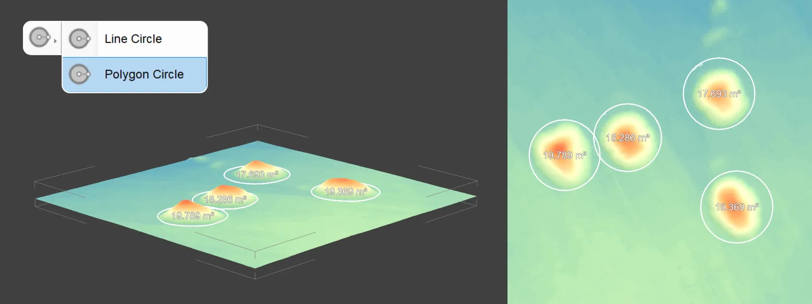
Add Circle draws either a line circle or a polygon circle. A finished circle gets an Edit as Circle option in its right click menu, so you can change the radius by dragging in the 3D view and it keeps a perfect shape. The Tools panel shows the radius.
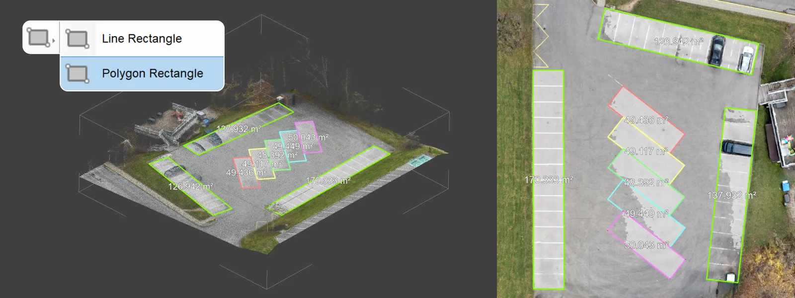
 Add Rectangle draws a line or polygon rectangle. While drawing, the Tools panel on the right shows its position, width, height and angle, and you can type in exact values. A finished rectangle can be moved, rotated and resized.
Imported Point Clouds Can Now Be Meshed
Imported dense point clouds can now be turned into a mesh, which earlier versions could not do. Import works as before: right click the Point Clouds layer group and choose Import Point Cloud, with .las, .laz, .ply and .xyz supported.
If the project also has a sparse reconstruction, Pixpro can compute per-point camera visibility for the imported cloud, using the Compute Point Visibility option in the import dialog or in the layer's right click menu. With visibility computed, the imported cloud is meshed the same way as a cloud generated in Pixpro.
Read more: Importing and exporting in the Pixpro help
Much Faster Layer Preparation
After a DEM, orthophoto, dense point cloud or mesh is generated, Pixpro builds the display chunks that let you view it. That step is now much faster, with identical output, so large layers become available noticeably sooner after generation and after Recreate Chunks.
Other Improvements
- Keep points with 2 projections, in Options under Processing and off by default, now also works with the Global and Triangulation mappers. It keeps less reliable points seen in only two photos, which can help photo sets with low overlap.
- Dense point cloud generation no longer fails if the GPU crashes. It continues on the CPU, and a GPU or CPU choice has been added in Options under System.
- Batch processing continues when a project fails, and lists the failed and cancelled projects at the end. Batches with only later steps selected no longer delete the existing results.
- Measurements on a partly loaded elevation model now show "Not Available" instead of crashing.
- Reconstruction can reuse already generated features and matches after a crash or a cancel.
- Projects with accented or non-Latin characters in folder or file names now work for mesh and point cloud import and export, textures, depth maps and GCPs from photo metadata.
- Measurement fixes: polygon volumes in printed reports now match the 3D view when a custom base plane height is used, polygon Area 3D (surface) is the same in the 3D view and the report, and the slope angle option now works in line profile snapshots and prints.
- GCP fixes: the properties panel shows the real number of estimated projections, and CSV projection import tolerates spaces after commas and reports names it could not match.
- Performance: deleting photos from large sets no longer takes minutes, large photo imports show progress instead of looking frozen, and closing a textured mesh layer frees its GPU memory.
- Cloud: a warning before upload when photo file names are too long, and cloud reconstruction now keeps the uploaded project's photo positions and camera calibrations.
- Summary and Help now open in your default browser, and orthophoto generation no longer silently fails in the Filling holes step on computers with many CPU cores.
Conclusion
Most of what makes 1.8.0 important is invisible once it works. The reconstruction step decides whether a project succeeds at all, and the Adaptive preset means Pixpro now tries more than one way of solving it before giving up, without you having to know which mapper suits which data. That alone should mean fewer projects that need a second attempt.
As always, a lot of this release comes from real projects and real feedback. If something does not work the way you expect, or you are missing a feature, get in touch by email or on Discord.
Frequently Asked Questions
What is new in Pixpro 1.8.0?
A new reconstruction core with the Global and Triangulation mappers, Mapping Effort presets with an Adaptive default, Extended Referencing for unreliable GPS, a Slope Map layer, Circle and Rectangle tools, meshing of imported point clouds, much faster layer preparation and many stability fixes.
Which Mapping Effort preset should I use?
Adaptive, for most projects. It tries the Global, Incremental, Hybrid and Triangulation mappers in turn and keeps the first result that registers more than 85 percent of the photos. If you know your data, for example an RTK drone set, you can choose a single mapper directly.
What is the difference between the Global and Triangulation mappers?
Global solves the whole scene at once and works with or without GPS. Triangulation places the cameras directly at their recorded GPS positions and angles, so it always needs GPS, and it is the fastest option for RTK drone photo sets.
Can I open Pixpro 1.8.0 projects in older versions?
No. Projects converted to 1.8.0 cannot be opened in earlier versions. Pixpro asks before converting, and leaves the project untouched if you decline, so keep a copy if you still need the older version.
What does Extended Referencing do?
It repeats the photo GPS referencing up to five times, each time leaving out more of the photos whose GPS fits worst, and keeps the best result. It can fix models tilted by poor consumer drone GPS, but not always. Ground control points or manual referencing remain the reliable fallback.
Related Blog Posts
Our Related Posts
All of our tools and technologies are designed, modified and updated keeping your needs in mind

Why Choose Pixpro Photogrammetry Software? Practical Comparison
There is no shortage of photogrammetry software today. From well established industry tools to newer cloud based solutions, the choice is not exactly obvious, especially for someone just getting started. Most options promise high accuracy, automation, and ease of use, and to some extent they all del
 Pixpro Team
3D Point Clouds in Pixpro: How to Convert and Export Spatial Data
Photogrammetry software produces several types of spatial outputs, but the dense 3D point cloud is the foundation of them all. In Pixpro, the dense point cloud acts as the base dataset from which every other derivative is generated.
Pixpro Team

How to Create and Import a KML File in Pixpro Waypoints
We are continuing our improvements to the Pixpro Waypoints service and bringing a few small updates. Pixpro Waypoints is a service that allows automatic photogrammetry flights with consumer grade DJI drones using a bit of workaround magic.
Pixpro Team
Ready to get started with your project?
You can choose from our three different plans or ask for a custom solution where you can process as many photos as you like!
Free 14-day trial. Cancel any time.
Welcome to Pixpro
Sign in
And access your account.