.svg@webp)
Photogrammetry Calculator – GSD, Flight Speed and More
 Lukas
Zmejevskis
Lukas
Zmejevskis
Using our experience in aerial photogrammetry and client support, we created the Pixpro Photogrammetry Calculator. It should help to study and execute automatic and manual photogrammetry flights. With these calculations, you will be more prepared for the upcoming flight, knowing what quality and time consumption to expect. Also, you can use this as a sanity check on already-acquired photo sets. This article will explain the reasoning behind this calculator and how to use it.
You can download it for local use or save it to your personal drive by going to File>Make a copy. Once you do that, you will be able to edit the sheet.
Photogrammetry Calculator Input Data
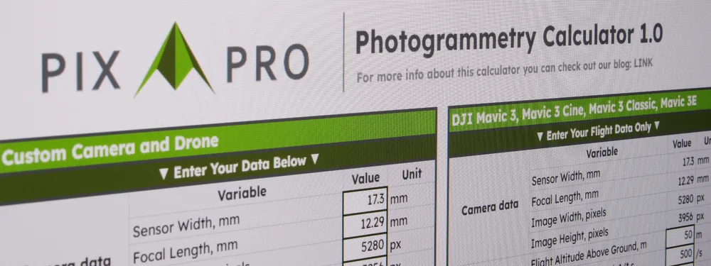
We can input eight variables into this spreadsheet in the “enter your data below” section, subdivided into camera and flight data groups. More information on these variables from top to bottom:
- Sensor width – the physical dimension of the imaging sensor inside the camera.
- Focal length – is a physical measurement of the lens in front of the sensor. It is vital to all calculations as this allows us to calculate the field of view of the whole camera system.
- Image width – the longer edge of the image, expressed in pixels.
- Image height – the shorter edge of the image, expressed in pixels.
- Flight altitude above ground – your desired flight height.
- Camera shutter speed – the most critical exposure variable when taking photos while moving. If the shutter speed is too low, the images can get blurry and, therefore, unusable for photogrammetry. It is crucial to keep the shutter speed under control to get good-quality photos.
- Photo interval – the time duration between taking sequential photos. It is essential if we are using time shooting for our manual or semi-automatic flights. We can select the interval in the flight app, which is usually two seconds at the minimum.
- Desired vertical overlap is the overlap between sequential images when flying forwards or backward (not sideways, which would need horizontal overlap calculations). We recommend keeping this at 80 percent at all times.
We can find camera data in spec sheets, photo metadata (EXIF), or the internet. The flight data variables are up to the user to determine. In this calculator, we included 5 “presets” of the most popular drones on the market, so there is no need to search for those values.
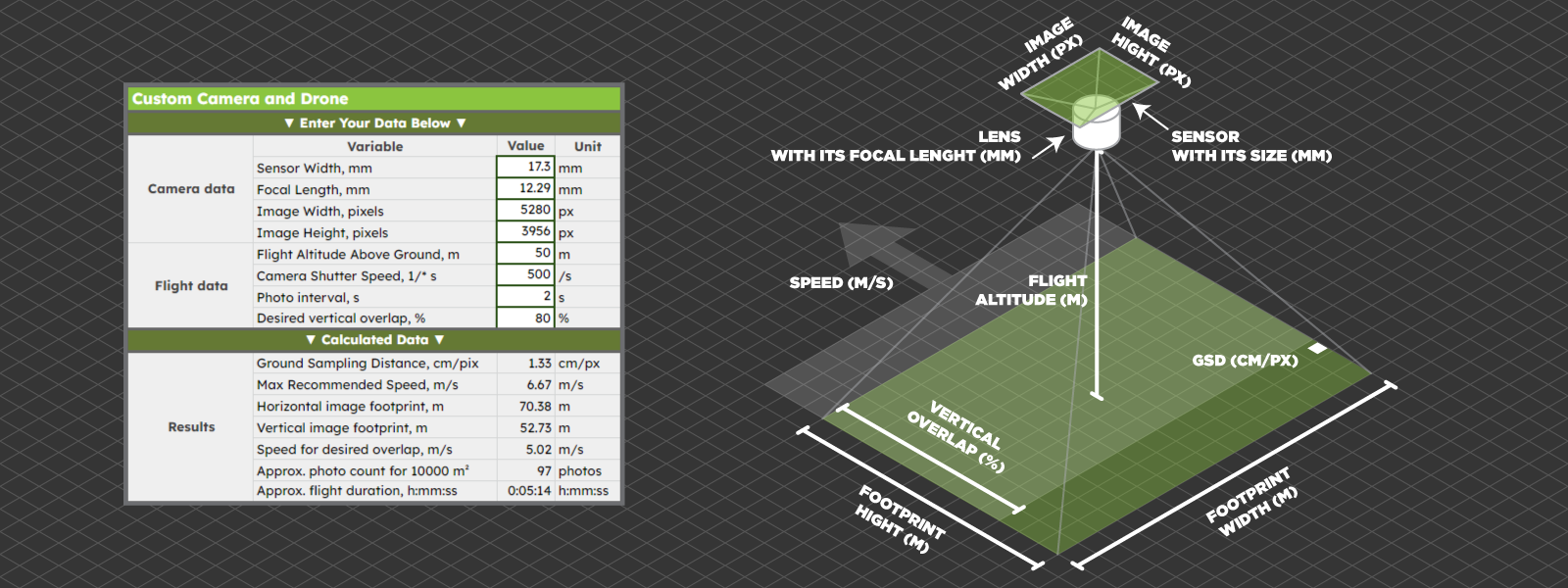
Photogrammetry Calculator Results
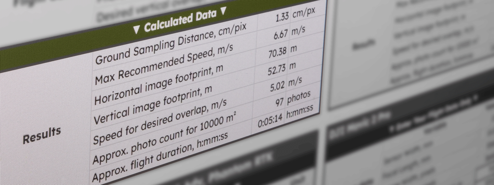
Currently, the calculator gives us 7 data points as results. Let us provide more detailed information on what you are getting:
- Ground sampling distance – this value allows us to get an idea of the potential quality of the photoset. The smaller this value is – the less space in real life a single pixel represents, which means – a higher resolution.
- Maximum recommended speed – this is a theoretical speed we can not exceed to keep a photo sharp for the given shutter speed. The theoretical limit is often relatively high and does not account for other types of movement besides linear flight. We always recommend staying way below the allowed maximum speed.
- Horizontal image footprint – gives an idea of how wide the camera sees when facing directly downwards in real life.
- Vertical image footprint – same as horizontal but vertical. These values also serve as intermediaries for other calculations.
- Speed for the desired overlap helps determine the flight speed for semi-automated flights at given photo capture intervals needed to achieve the overlap. This formula has some leeway built into it so you can safely use the value when executing a flight.
- Approximate photo count for 10 000 square meters – a rough estimation of how many photos will be needed to cover a 100×100 meter square with a 10-meter buffer zone.
- Approximate flight duration – a rough estimate of how much the flight should take. It varies wildly depending on many factors. But some additional time for takeoff is built into the calculation, so this should provide a reasonable ballpark estimate for your aerial photogrammetry flight.
Use cases
We can use this sheet to prepare for automated, manual, and semi-automatic flights. You can determine the GSD value you will get at different flight altitudes without having to fire up your flight planning software. The maximum speed recommendation allows you to limit your flight speed if the planning app does not have a feature like this.
Approximate photo amount and time calculations help to get an idea of the scope of the work ahead. While the footprint calculations give an understanding of the camera angle in real life when pointing the camera directly down (nadir scan).
This calculator is vital when using waypoints where you can set the photo interval and speed of the drone. Using the data here, you can reliably get 80 percent overlap and use waypoint missions for photogrammetry. In our next article, we will look at how to use waypoints for photogrammetry.
Conclusion
We created this photogrammetry calculator to help anyone to analyze flights even before they happen. Good planning is vital to making successful aerial photogrammetry scans, and we hope this will have some use for you. If you want us to add more calculations for additional results or more drones as presets, contact us at info@pix-pro.com, and we can make a 2.0 version even more helpful.
Photographer - Drone Pilot - Photogrammetrist. Years of experience in gathering data for photogrammetry projects, client support and consultations, software testing, and working with development and marketing teams. Feel free to contact me via Pixpro Discord or email (l.zmejevskis@pix-pro.com) if you have any questions about our blog.
Related Blog Posts
Our Related Posts
All of our tools and technologies are designed, modified and updated keeping your needs in mind
Overlap Between Different Perspectives
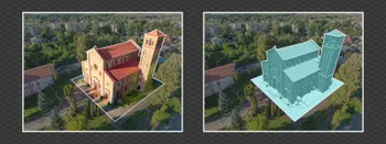
Photogrammetry can be simple and rigid or complex and adaptable. Combining different scan patterns adds complexity to the work but improves detail and coverage. We often use examples of combined flights, of which the orbital + nadir grid is a classic. They provide great 3D structure while being easy
Pixpro Waypoints - Automated Photogrammetry Flights for Newest DJI Drones
The latest DJI drones are the most capable flying cameras on the market. If you need a tool like that or a competent machine for casual creation - DJI Mavic 3, DJI Mini 4, and DJI Air 3 series drones are the best.

Accuracy of Your Photogrammetry Project
Accuracy in photogrammetry is a multifaceted point of discussion. We can talk about absolute, relative, or even geometric accuracy, to name a few. No tool or technique can really prove anything beyond reproach.
Ready to get started with your project?
You can choose from our three different plans or ask for a custom solution where you can process as many photos as you like!
Free 14-day trial. Cancel any time.