.svg@webp)
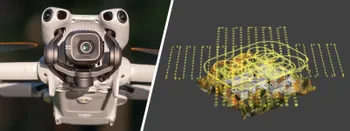
Ground Sampling Distance Visualized
 Lukas
Zmejevskis
Lukas
Zmejevskis

Ground sampling distance (GSD) is a ubiquitous term in photogrammetry. While this acronym often describes a specific scan quality aspect, it may be misunderstood or overvalued. This article will examine GSD practically and provide real-world examples illustrating how different GSD values compare in real examples.
The Ground Sampling Distance Metric
Ground sampling distance is a value that describes a linear distance represented by a single pixel in a raster image - a photo. We find GSD most commonly when evaluating aerial capture data to explain the resolution you may expect from an orthophoto image. To fully understand this metric, one must know a few critical things in addition:
The nominal GSD value depends on the flight height, camera sensor resolution, and camera lens field of view. GSD may not accurately represent the final product's quality due to poor lens quality, an inflated megapixel amount for quad-bayer sensors, or atmospheric haze from high-altitude flying.
 No project has a genuinely uniform GSD. The GSD value will always fluctuate because a surface is never perfectly flat or the flight is perfectly parallel. So, GSD is usually an approximation or a precise value only for the drones' takeoff location.
GSD value becomes extremely variable for oblique capture and should not serve as a reliable metric.


Practical Considerations with GSD
If you have a target GSD you have to hit for scientific papers, clients, or other purposes, always undershoot and aim for a slightly smaller value. In practice, this means flying a bit lower, thus increasing the time of the flight and the number of photos. However, it is a safe bet unless the GSD number is only a rough guideline and will not stand scrutiny.
The GSD number will also mean nothing if the reconstruction quality variables are subpar. We preach this a lot, but image quality, consistent overlap, and coverage are the fundamental pillars of photogrammetric quality. The calculated GSD value is just a number and is only valid when the fundamentals are strong.
 READ MORE AND TRY OUT PIXPRO WAYPOINTS SERVICE FOR NEWEST DJI DRONES
Other Quality Metrics?
We often encounter people caring about other metrics who may think that more means better. We are talking mainly about the number of dense cloud points and triangles in a mesh. Structural quality and absolute and relative accuracy will not directly relate to these numbers.
More triangles in a mesh may mean more detail in the 3D model if the scale is the same, but it is quantitative. The same applies to the number of points in a point cloud and to the nominal raster resolution of a digital elevation map.
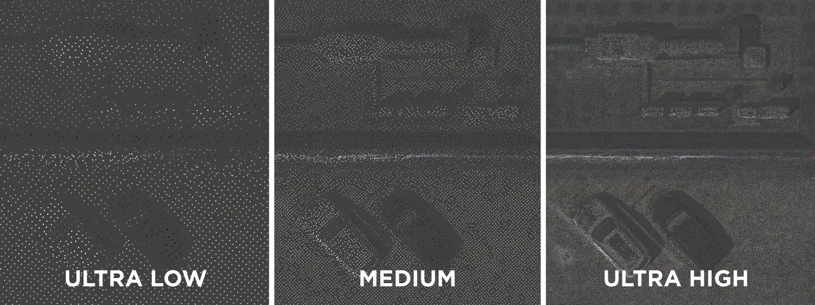 These numbers are also a matter of photogrammetric processing settings. Yes, we can choose ultra-high or ultra-light-dense point cloud settings, which may heavily impact the number of points ultimately generated in a cloud. But, again, the overall quality of the scan will remain the same and may only have some specific impact in tiny detail areas that can benefit from a more aggressive densification process. The limiting factor ultimately will be each photo's actual photographic resolution (detailedness, not pixel dimensions).
Side by Side Examples
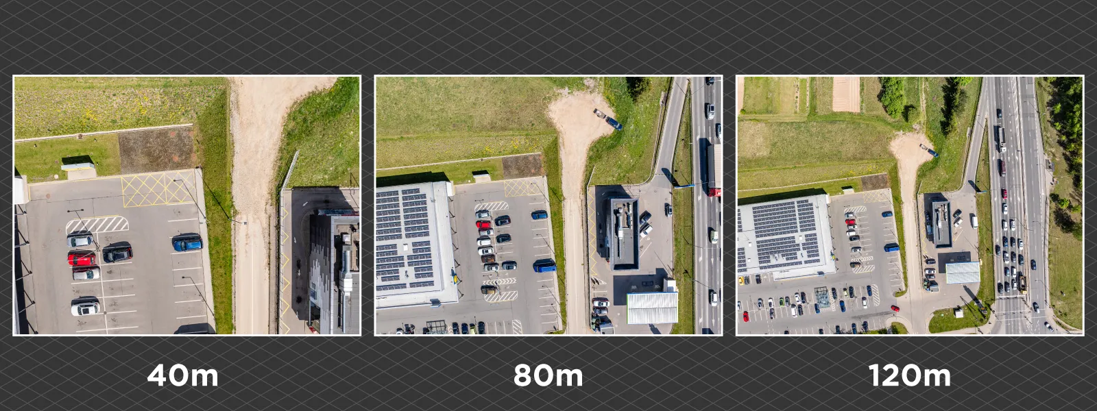
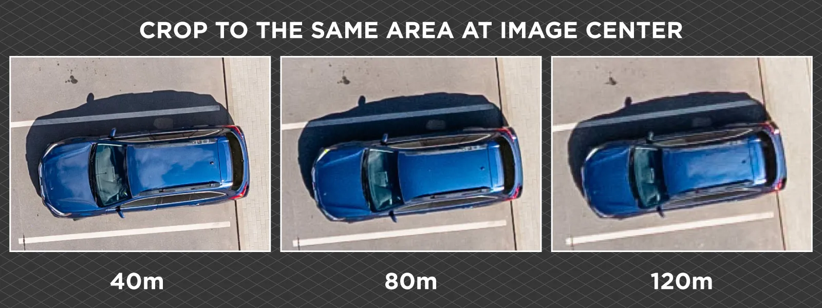
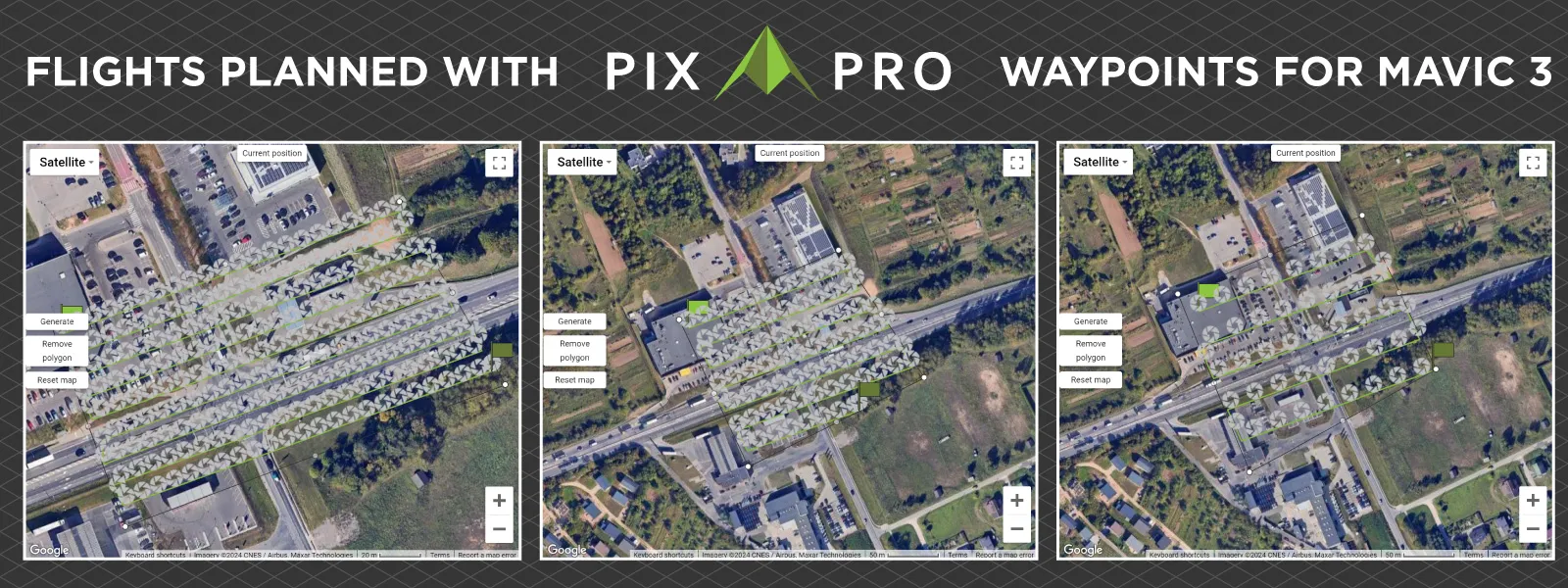
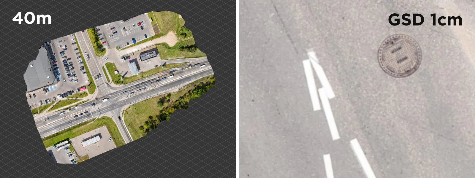
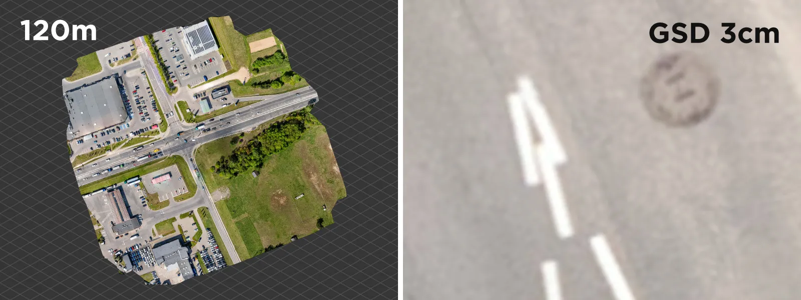
We made three scans of the same area to show a difference in detail adjusting altitude makes. The scan is of a busy crossroad, and we did nadir grids with the Mavic 3 and using Pixpro Waypoints service. To do justice to the comparison, we need to make an orthophoto larger than the maximum resolution of photo GSD.
40-meter height flight: nominal photo GSD 1.07 centimeters/pixel. Required photo amount: 212. Orthophoto example created with 1 centimeter GSD setting, and the total dense point cloud points on a medium setting were 8929889. Flight time: 7 minutes.
 80-meter height flight: nominal photo GSD 2.13 centimeters/pixel. Required photo amount: 79. Orthophoto example created with 2 centimeter GSD setting, total dense point cloud points on a medium setting - 3768860. Flight time: 5 minutes.
 120-meter height flight: nominal photo GSD 3.2 centimeters/pixel. Required photo amount: 49. Orthophoto example created with 3 centimeter GSD setting, total dense point cloud points on a medium setting - 2995977. Flight time: 4 minutes.
 Conclusion
We hope this short article will further the accurate, practical understanding of GSD and dispel any myths surrounding it for many photogrammetry beginners or professionals. If we missed something or need to go deeper regarding ground sampling distance understanding, write in the comments below.
Photographer - Drone Pilot - Photogrammetrist. Years of experience in gathering data for photogrammetry projects, client support and consultations, software testing, and working with development and marketing teams. Feel free to contact me via Pixpro Discord or email (l.zmejevskis@pix-pro.com) if you have any questions about our blog.
Related Blog Posts
Our Related Posts
All of our tools and technologies are designed, modified and updated keeping your needs in mind
Stockpile Volume Measurement With Drone Photogrammetry: A Practical Guide
Measuring a stockpile sounds trivial until you actually have to do it on a real site. You need a number you can defend at the end of the month, and you would rather get it without sending somebody to climb up a 10 meter mountain of gravel with a GPS pole.
DJI Lito X1 for Photogrammetry
Can the Lito X1 be used for photogrammetry? Yes it can. Can it produce good results? Yes it can. How to do it? Yes it… well, that is what the rest of this article is for.
DJI Mini 5 Pro For Photogrammetry – Aerial Scanning With Pixpro Waypoints
DJI Mini 5 Pro is a 250-gram flying camera equipped with a 1-inch type sensor. Nine years ago, the Phantom 4 Pro was released as the first consumer drone to feature the same sensor format.
Ready to get started with your project?
You can choose from our three different plans or ask for a custom solution where you can process as many photos as you like!
Free 14-day trial. Cancel any time.