.svg@webp)
Pixpro photogrammetry blog
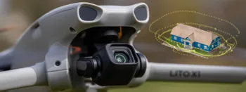
DJI Lito X1 for Photogrammetry
Can the Lito X1 be used for photogrammetry? Yes it can. Can it produce good results? Yes it can. How to do it? Yes it… well, that is what the rest of this article is for.
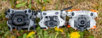
DJI Lito X1 vs Mini 5 Pro vs Mini 4 Pro: Which Sub-250g Drone Should You Buy?
Three current sub-250 gram DJI drones, almost identical on paper, all sitting on the same shelf. The DJI Lito X1, the Mini 4 Pro, and the Mini 5 Pro each have a clear value proposition, but the differences are small enough that picking the right one is a real question.
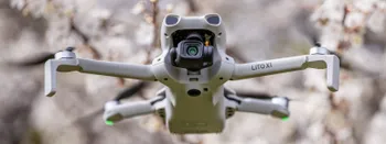
DJI Lito X1 Review: Specs, Flight Impressions, and How It Compares to the Lito 1
DJI recently launched a new drone series called Lito. It consists of two drones, the Lito 1 and the Lito X1. Both are sub-250 gram drones aimed at the more affordable end of the small drone segment.

Top 10 Photogrammetry Misconceptions Part 2 – Advanced Myths
A while back I published a list of the most common photogrammetry misconceptions I kept running into. That post focused on the basics: gear, megapixels, settings, and other things beginners often get wrong.
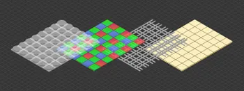
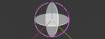
Camera Sensor Technology Explained – Stacked, Partially Stacked, BSI, IBIS, and What It All Means
Camera sensor technology is one of those topics that sounds complicated but really comes down to a few core ideas. Most photographers interact with the results of sensor design every day without thinking about how the sensor actually works.

What Actually Affects Photogrammetry Accuracy?
Photogrammetry accuracy is one of those topics that seems straightforward at first. You take photos, run them through software, and expect accurate results. In reality, it does not quite work like that.

Why Choose Pixpro Photogrammetry Software? Practical Comparison
There is no shortage of photogrammetry software today. From well established industry tools to newer cloud based solutions, the choice is not exactly obvious, especially for someone just getting started. Most options promise high accuracy, automation, and ease of use, and to some extent they all del
Vertical Coordinate Systems in Photogrammetry – Ellipsoid vs Geoid Explained
Vertical coordinate systems usually go unnoticed until something stops matching. A model aligns perfectly in 2D view, but elevations are off. Volumes look reasonable, yet they do not match survey results.
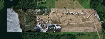
Large Property Photogrammetry – Real Estate Development Use Case
Property scans are one of the most common use cases, especially for our software. Pixpro is affordable and works well with RTK data and ground control points when necessary.
Ready to get started with your project?
You can choose from our three different plans or ask for a custom solution where you can process as many photos as you like!
Free 14-day trial. Cancel any time.
Welcome to Pixpro
Sign in
And access your account.