.svg@webp)
Monitoring and Inspection
Blog posts and use cases for monitoring and inspection applications.
3D Roof Scanning with the DJI Mini 5 Pro
Another entry in our ongoing exploration of roof photogrammetry workflows. This time, the subject is the DJI Mini 5 Pro — DJI's latest 250g drone with a 1-inch sensor, omnidirectional obstacle avoidance, and Pixpro Waypoints support.
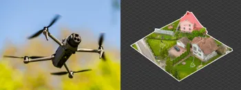
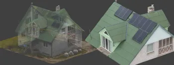
Residential House Scan Use Case - Complete Exterior
Dealing with a moderately complex request: a brand-new home building scan for documentation and solar panel installation planning. I had no opportunity to preplan any flights – just grab the drone and head to the location, with only a few listing photos as reference.

Observation Tower Inspection – Dual Lens Hyperlapse
Orbital flights are fundamental in photogrammetric scanning, especially when working with isolated structures such as towers, chimneys, monuments, or small buildings. They allow for detailed, wrap-around imagery of a subject using relatively simple flight paths and minimal setup.
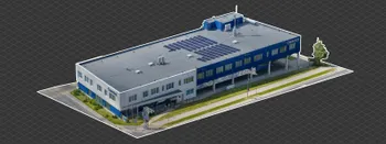
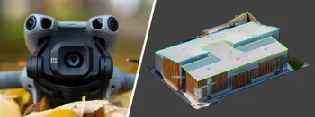
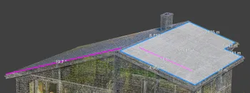
Industrial Building and Roof Scan - Use Case Details
For this use case, I have an industrial building requiring a reasonably detailed 3D reproduction for inspection, solar panel expansion, and general documentation.
3D Roof Photogrammetry with DJI Mavic 4 Pro
3D roof photogrammetry is the best way of measuring, inspecting, and evaluating roofs in many use cases. Our most common use case is either inspection for renovation or solar panel installation and energy simulation.
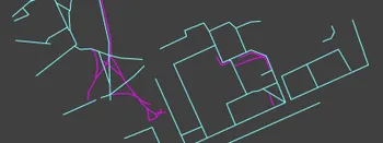
Natural Pathway Formation - Measurement and Monitoring Aerial Photogrammetry
People do not like inefficiency. Sometimes, it is such a subconscious drive that we do not even think about it. A good manifestation of that is "naturally" occurring paths.

Video Frames vs. Photos for Photogrammetry
Photogrammetry uses raster data to calculate a 3D scene. Raster is just another word for images made out of pixels. So, taking photos is the fundamental first step of creating a scan.
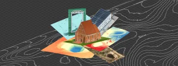
Where do we use Photogrammetry? A list of 3D scanning use cases.
Photogrammetry has revolutionized numerous industries by transforming real world scenes into 3D models, using only simple photographs and processing algorithms.
Roof Scan for Inspection and Solar Panel Addition – Use Case
Roof photogrammetry is one of our client base's most common use cases. Obtaining accurate measurements is essential for designing a solar panel layout, determining how many panels fit on a roof, and conducting a prior inspection.
Ready to get started with your project?
You can choose from our three different plans or ask for a custom solution where you can process as many photos as you like!
Free 14-day trial. Cancel any time.
Welcome to Pixpro
Sign in
And access your account.