.svg@webp)
Photogrammetry for Building Demolition - Volume Measurements
 Lukas Zmejevskis

As photogrammetry software developers, we at Pixpro have the opportunity to work with professionals from many fields. Demolition and material removal are some areas in the construction industry that can significantly benefit from photogrammetric workflows. In this article, we will share our findings on how photogrammetry can help to work more accurately and efficiently when evaluating the amount of material and other aspects before building demolition and material removal.
Main Challenges
One of the main challenges in building demolition and dismantling is predicting the total value of the contract work. To get accurate estimates for profitable and competitive contracts, companies need a quick and efficient way of evaluating the type and amount of potential waste material alongside other factors such as accessibility and safety of the site. There is no better way than capturing the entire area with a drone and having a 3D scene with proper scaling that anyone in the company can look at from the comfort of their workplace.
Aerial photogrammetric capture and Pixpro software enable us to do just that in a few hours. A quick scan can be acquired using any competent drone and a bit of know-how. At the same time, Pixpro provides quick and easy measurements after a single button click data processing. We made some examples to demonstrate the entire process.
Aerial Photogrammetry Flights
We use orbital scans to get a reasonably high-quality 3D scene for initial estimation. Orbital scans provide enough data for good 3D reconstruction, which means accurate measurements and realistic enough 3D visualization to evaluate the entire scene from any perspective.
Also, orbital flights are accessible for consumer-grade drone pilots via hyperlapse modes or POI tracking. So an enterprise drone with automated flight planning is unnecessary for such an application. For our examples, we used the best consumer-grade drone on the market - DJI Mavic 3 Pro. A cheaper Mavic 3 Classic would provide identical results, and a Mini 3 Pro would be almost as good. These are the drones we recommend besides the more expensive enterprise-grade Mavic 3E.
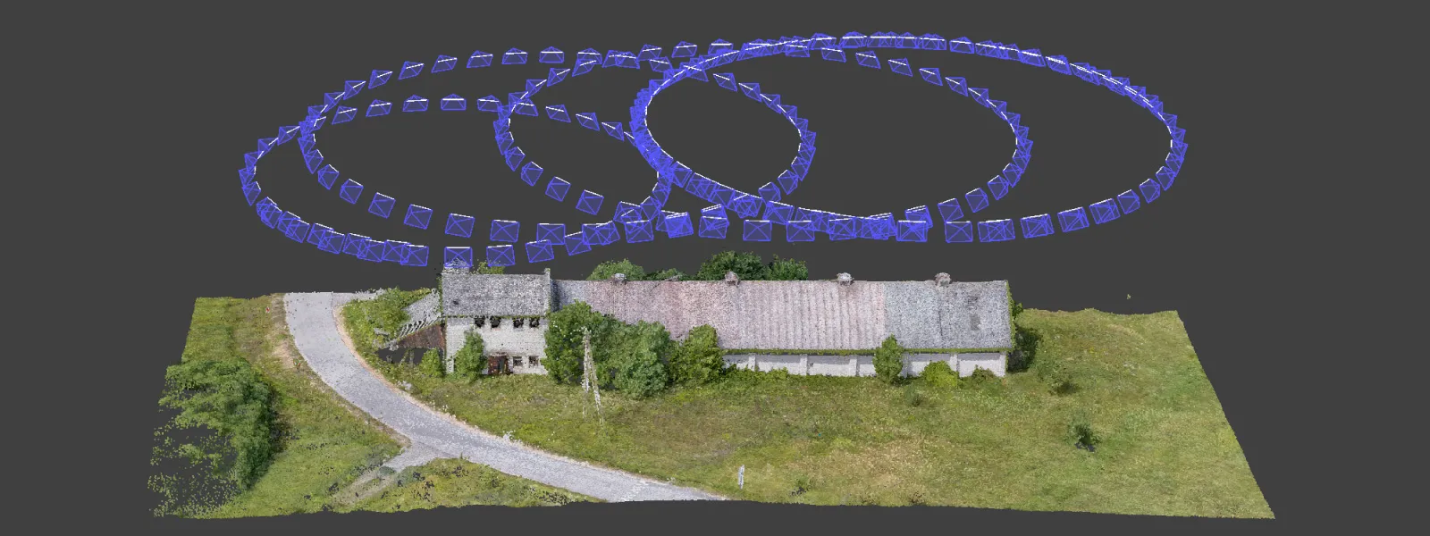
An important thing to get right is the balance between the number of photos and desired quality of the project. The lower the flight altitude - the better detail you will get while needing more photographs for full coverage. We aimed to do something right in the middle choosing flight altitudes from 15 meters for the smallest objects and 80 meters for the largest.
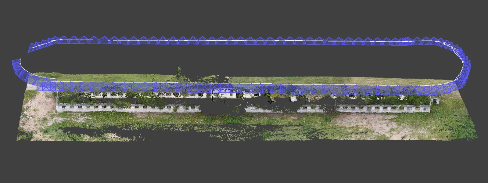
We also did some manual perimeter scan type flying while using the cruise control feature in timed shot mode. For an especially elongated object a perimeter scan is an even more efficient option than multiple orbitals, albeit providing less detail overall.
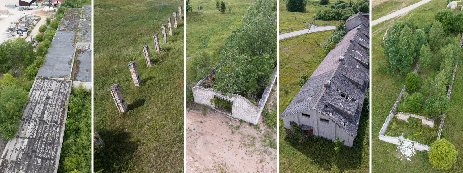
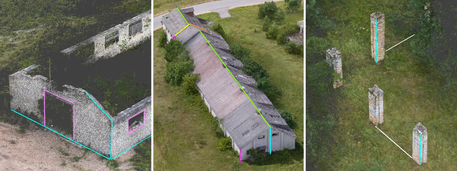
We chose highly challenging examples, ruins of buildings with extremely overgrown vegetation during a windy day. Trees and wind do not play well with photogrammetry due to constant movement and will result in a lot of noise. However, the ruins - our subject - remain stable and basic measurements are easily obtainable, from which we can easily calculate the volume of potential waste material.
We needed multiple orbits for each scene to cover all objects with reasonable detail. We can divide any location into equal sections following the shape of the main subject, as we did in our previous article.
Aerial Photogrammetry Data Processing
We processed the photos in Pixpro photogrammetry software. Processing in Pixpro is relatively straightforward, but you can use cloud or local processing. Cloud processing generates the project on our server and allows downloading it if you do not possess a powerful PC. If you do, you can utilize local processing, which will take minutes to hours, depending on the amount of photos and the strength of the hardware.
Photogrammetric Data Analysis
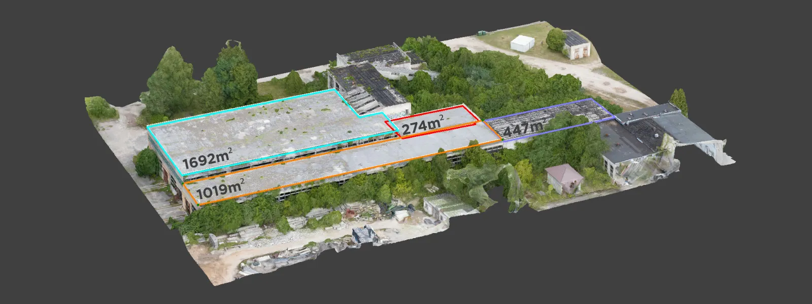
We can use point clouds, meshes, or elevation maps for data analysis. With Pixpro, we can obtain linear measurements from all of these layers. In contrast, volumetric measurements are available only on digital elevation maps or DEMs. The most visually pleasing results will be the complete 3D model - 3D mesh with texture.
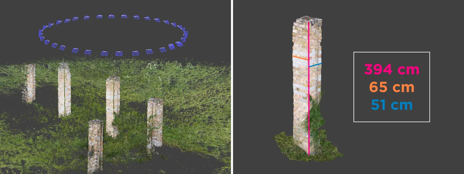
We can measure the exact height of each part of the building and ruins with linear measurements—also, open wall thicknesses and distances to the nearest road or potential work site. We can also measure the area and terrain slopes of the surroundings to avoid accidents with heavy machinery or choose a spot requiring less terraforming for the equipment.
These are the primary data analysis tools besides visual inspection. We can export this data as simple .pdf reports, which we can share with anyone interested. Also, any object we draw will remain in the project, which has no limitations on being shared and opened on other computers with Pixpro software.
Conclusion
Photogrammetry is easy and efficient and should replace any other aging workflows, such as physical measurements of hardly accessible objects or inaccurate methods, such as looking at low-resolution satellite imagery. Even with trees, vegetation, and problematic weather conditions, aerial photogrammetry is a type of remote sensing that increases the effectiveness and safety of analyzing any 3D scene, which is possible to 3D scan. Accurate measurements and visual inspection will enable all construction industry professionals to make better decisions and avoid deviating from estimations.
Photographer - Drone Pilot - Photogrammetrist. Years of experience in gathering data for photogrammetry projects, client support and consultations, software testing, and working with development and marketing teams. Feel free to contact me via Pixpro Discord or email (l.zmejevskis@pix-pro.com) if you have any questions about our blog.
Related Blog Posts
Our Related Posts
All of our tools and technologies are designed, modified and updated keeping your needs in mind
DJI Lito X1 for Roof Photogrammetry: Solar and Inspection Use Case
Small drones are the best tool for residential and even commercial roof photogrammetry. They are quiet, attract less attention, are easier to fly fully within regulations, and they are affordable.
Large Property Photogrammetry – Real Estate Development Use Case
Property scans are one of the most common use cases, especially for our software. Pixpro is affordable and works well with RTK data and ground control points when necessary.
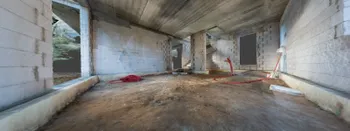
Handheld Photogrammetry Construction Interior Scan Use Case
Interior 3D scanning can be useful in a myriad of ways. In this article, I present a scan of a residential building construction site, with its foundation walls and roof almost complete. Further construction will require some visualizations and design according to “the fact.”
Ready to get started with your project?
You can choose from our three different plans or ask for a custom solution where you can process as many photos as you like!
Free 14-day trial. Cancel any time.
Welcome to Pixpro
Sign in
And access your account.