.svg@webp)
Pixpro photogrammetry blog

Pixpro Tutorial Videos Part 1 - Essentials
Our Pixpro photogrammetry software is relatively easy to use, but everyone needs a starting point. We created a series of short videos that demonstrate how to begin using Pixpro even if you have never used the software before.

Accuracy of Your Photogrammetry Project
Accuracy in photogrammetry is a multifaceted point of discussion. We can talk about absolute, relative, or even geometric accuracy, to name a few. No tool or technique can really prove anything beyond reproach.
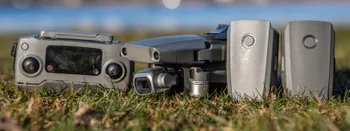
Buying a Used Drone - Mavic 2 Pro in 2024
Buying used gear is an excellent way to save money and obtain something that may not be on sale anymore. With drones reaching the 4th or 5th technological generation, the used drone market is becoming more extensive.

Photogrammetry Processing - Common Hardware and Software Issues
Photogrammetry requires complex processing and data crunching to turn photos into 3D models. We need a powerful machine to run the software and all its processes. Not only that, but the software within our machine may impact the performance of photogrammetry software in various ways.

Most Asked Photogrammetry Questions Part 2 - Pixpro Software
We created Pixpro photogrammetry software to bring photogrammetry to everyone. Our priority was always accessibility and ease of use. We think we did a good job designing software that is easy to use, and it takes just a few hours to understand all of the main features.

Most Asked Photogrammetry Questions - Our Answers Part 1
As software developers, we receive excellent feedback and questions from our existing and potential clients. Their questions range from what hardware to buy for photogrammetric processing to the best technique for a particular scanning scenario.
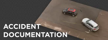
Quick Vehicle Accident Documentation with Photogrammetry
Photogrammetry is the ultimate form of documentation. If you are adept at doing photogrammetric scans, you can gather photographic data, resulting in a 3D scene that you can measure. Invaluable when the dependability of the data means solving disputes between people during legal processes.
True Orthophoto - Orthorectified Imagery and Pixpro Workflow
Orthorectified or true orthophoto concepts can still be misunderstood and confused with other types of aerial imagery, such as panoramas or orthomosaics. In this article, we revisit these concepts to explain why actual photogrammetry is necessary to create a true orthophoto.
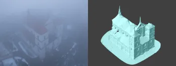
Weather Conditions for Photogrammetry - Rain and Fog
Winter in the northern hemisphere can be a severe limiting factor for millions of jobs. Including us - photogrammetrists who do aerial photogrammetry. In this blog post, we push the limits of wet weather and do some tests in heavy fog conditions and during light rain.
Ready to get started with your project?
You can choose from our three different plans or ask for a custom solution where you can process as many photos as you like!
Free 14-day trial. Cancel any time.
Welcome to Pixpro
Sign in
And access your account.